
Cheap flights to Bamako
Set your departure airport and maximum budget: SniperAir tracks prices to Bamako and alerts you the moment a deal matching your criteria appears.
Quick summary
Country
Mali
Continent
Africa
Airport
BKO
Currency
West African CFA franc (XOF)
Time zone
UTC
Deals already spotted to Bamako
Real flight examples detected by SniperAir, with their reference price.
Loading examples…
Why track Bamako with SniperAir
You do not need to compare prices every day
Choose your departure
Enter your departure airport and your maximum budget for a flight to Bamako (BKO).
SniperAir keeps watch
Our systems continuously compare new prices with the real price history of the route. SniperAir monitors prices and alerts you: it does not sell or book tickets.
You receive an alert
As soon as a price matches your criteria, you are notified, without having searched for anything yourself.
First, a plain statement: Mali is the subject of very restrictive official travel advice in many departure countries. That advice differs from one country to another, sometimes advises against travel to the country or to certain areas, and can even cover flights to Bamako. Do not assume the country is accessible to you: read the official advice of your departure country before considering anything, and check it again before any booking. SniperAir tracks prices and alerts you; it does not sell or book tickets and does not encourage you to travel.
This page therefore offers cultural and geographical background only. Bamako, the capital of Mali, stretches about twenty kilometres from west to east along the Niger, called the Djoliba here, in a basin ringed by hills, according to French Wikipedia. Its name is said to come from Bambara and to mean 'crocodile's backwater', the animal being the city's emblem. Population figures vary widely between sources and years, so we do not publish one.
Airport and getting into town
Bamako-Sénou, about fifteen kilometres to the south
Bamako – Modibo Keïta International Airport (BKO)
Modibo Keïta International Airport, also called Bamako-Sénou, lies about 15 km from the centre according to French Wikipedia and Wikivoyage (EN, FR). Wikivoyage (EN) mentions 30 to 40 minutes by road, a time that depends on traffic. French Wikipedia says it links the capital with regional capitals, other African countries and Paris. Airlines and routes change often, and in many departure countries official advice discourages some flights or travel altogether: check the position before buying anything.
Approximate distance and time, from Wikipedia (FR, ES) and Wikivoyage (EN, FR, DE). We quote no taxi fares and no list of airlines, which change.
A historic Dakar-Niger railway links Bamako with Kayes and Senegal according to French Wikipedia, but the state of the service is uncertain and Wikivoyage (EN, DE) describes it differently, so we do not list it as an option and refer you to official sources. The trans-Sahelian road from Dakar to N'Djamena passes through the capital; bush taxis and coaches leave from bus stations such as Sogoniko and Djikoroni, named by Wikivoyage (EN).
For any road journey inside the country, official advice often singles out areas to avoid. Do not build any route without reading it.
Landmarks
The Djoliba river, the bridges and the hills
Bamako is best understood through its river and its hills. The places illustrated below are described according to our sources; the other landmarks are covered in text only.
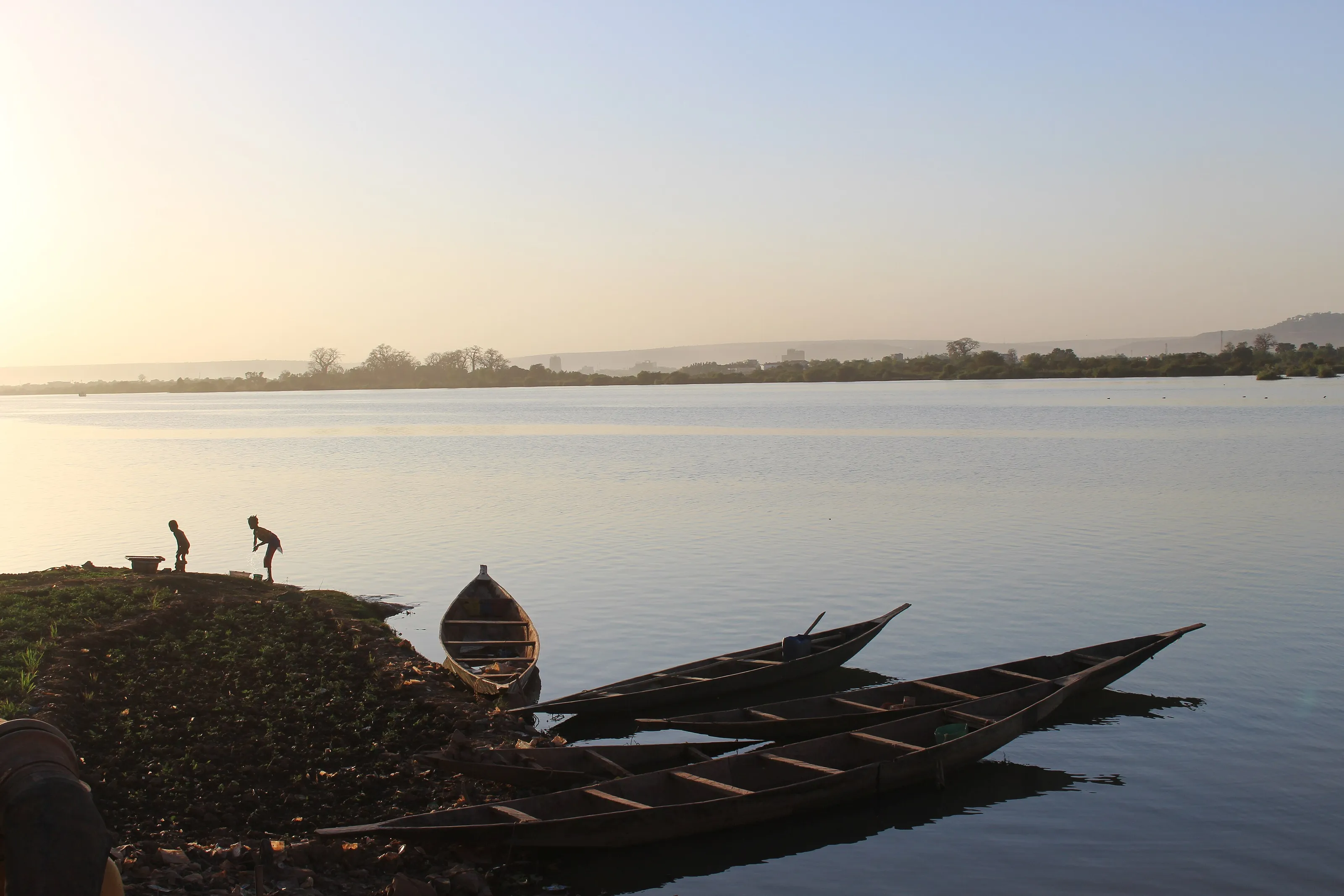
The Djoliba at the end of the day
According to French Wikipedia, the city is built on both banks of the Niger, called Djoliba, 'the river of blood' in Mandinka. Three bridges join the banks: the Pont des Martyrs, the King Fahd Bridge and the Sino-Malian Friendship Bridge. In this late-afternoon view, pirogues are moored on the bank, far from the main avenues.
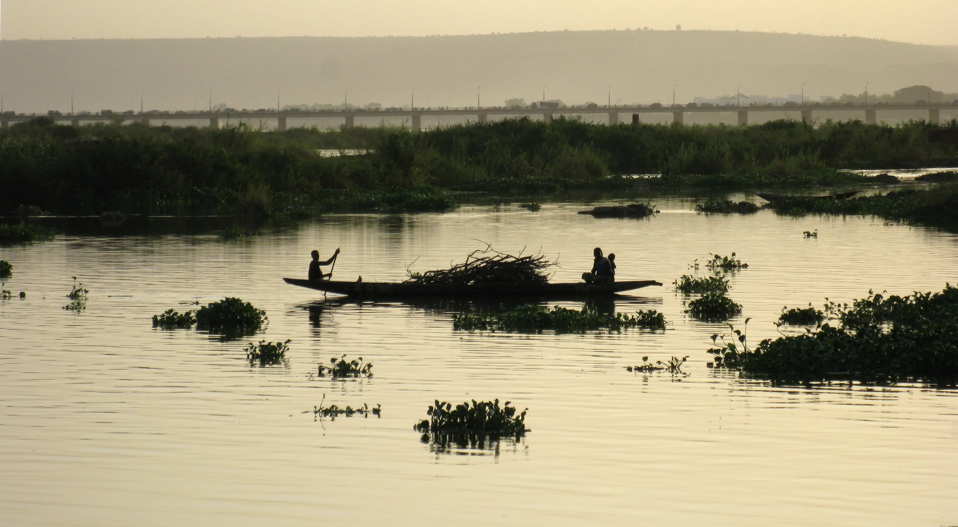
Pirogues and water hyacinths
Pirogues are still used for transport and work on the river; French Wikipedia notes that navigation is possible from Koulikoro onwards. Here a pirogue loaded with branches glides among water hyacinths, with a bridge in the distance in the evening light.
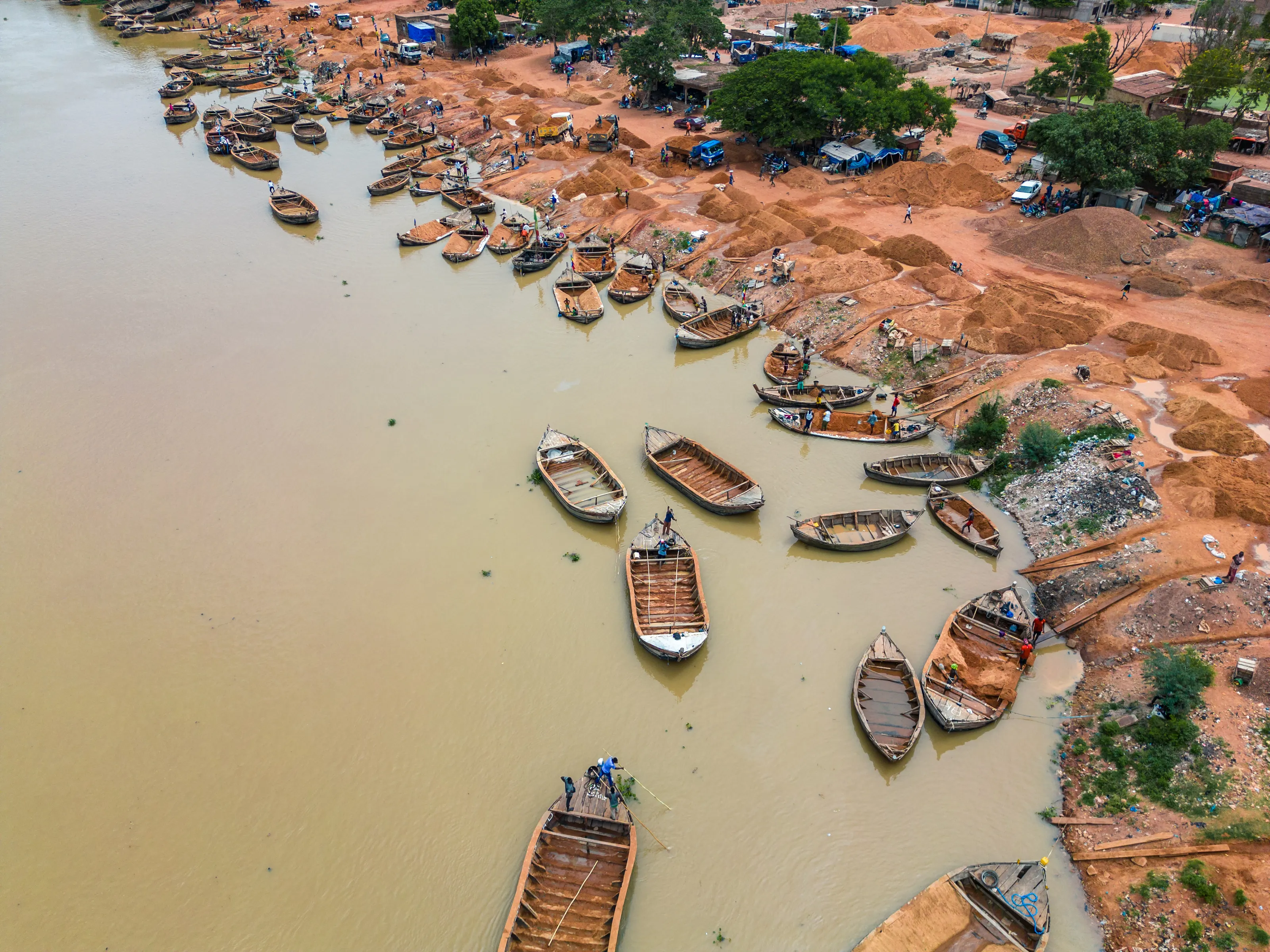
The river port and its boats
French Wikipedia describes Bamako as an important river port and a trading centre for the whole sub-region. This aerial view shows wooden boats lined up along the bank, beside heaps of orange sand unloaded on the shore.
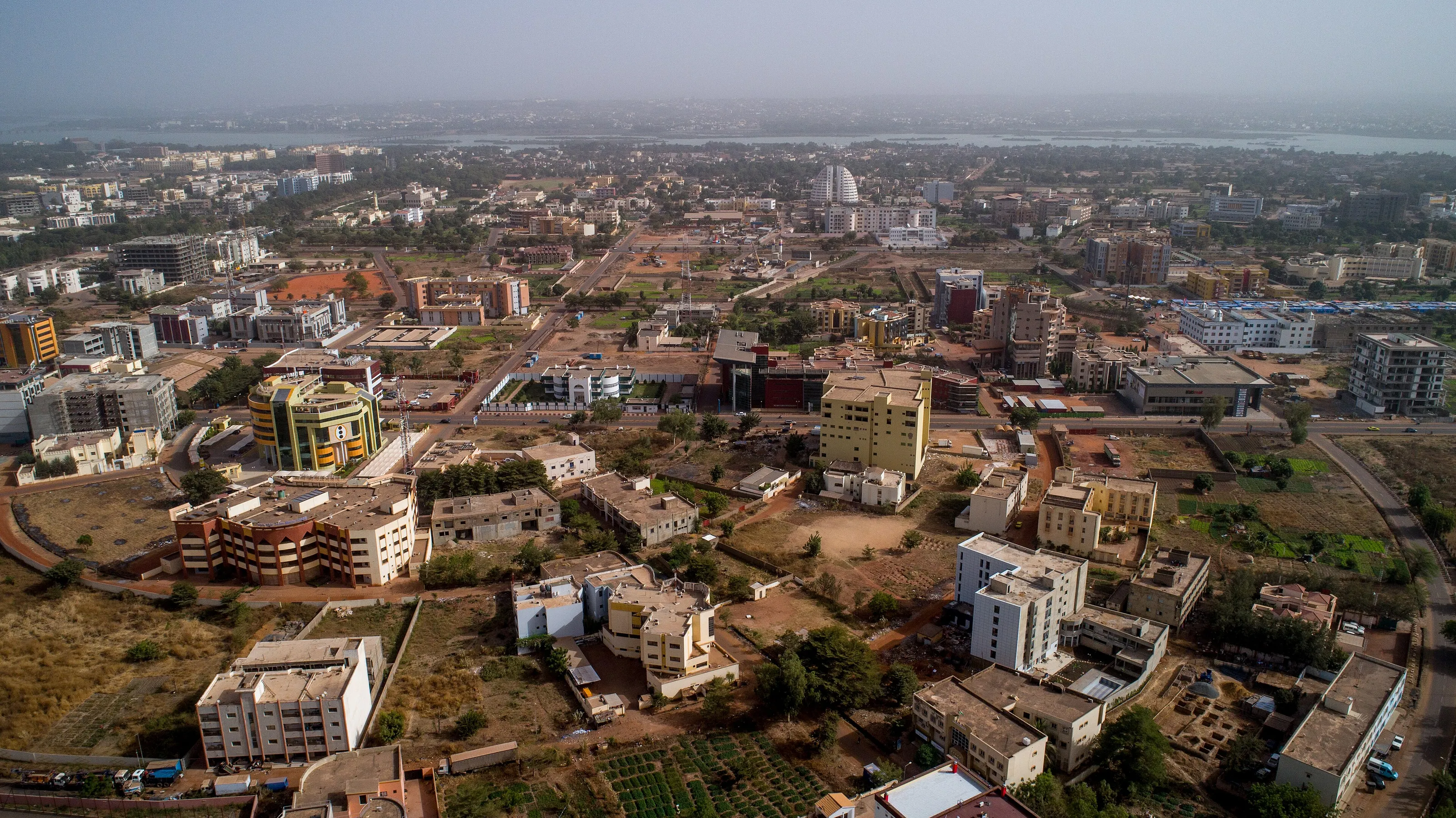
Recent districts seen from the sky
The ACI 2000 district, in the west, is described by Wikivoyage (EN) as quieter and removed from the bustle of the centre. In this view, low, colourful buildings stretch toward the river, which can be made out in the haze.
Other places named by Wikipedia (FR, ES, DE) and Wikivoyage (EN, DE): the Koulouba palace, built between 1903 and 1907 for the governor and seat of the presidency since 1960, on the hill Bamako people call the 'hill of power'; the Sacred Heart Cathedral and the Grand Mosque, built in the colonial period; the Independence Monument; the BCEAO tower, which Wikivoyage (EN) calls the tallest building in the country; and Point G hill. Access and opening times vary, so ask about the local situation before going anywhere.
Museums and culture
National museum, crafts and the cultural scene
The National Museum of Mali
Wikipedia (FR, ES) and Wikivoyage (EN) tell us this museum began in 1953 as the Sudanese Museum. It shows the country's ethnography: masks, textiles, statuary, contemporary art and prehistory. Its building, in stabilised mud brick inspired by Sudanese styles, is cited as an example of earth architecture; sources disagree on the date it moved there, so we give none. Hours and fees change, so we publish none.
Craft house and markets
French Wikipedia names the Maison des artisans, near the Grand Mosque, with goods in wood, gold, iron and leather, as well as the Marché rose, rebuilt after a fire, and the Médine market. Wikivoyage (EN) mentions an artisans' market in the Bamako-Coura district where bargaining is customary.
Palace of Culture and festivals
French Wikipedia presents the Palais de la Culture Amadou Hampâté Bâ, on the Niger, which hosts major artistic gatherings, and events such as the African Photography Encounters. Wikivoyage (EN) also mentions the Muso Kunda Museum of Women. Dates and programmes change and may be altered, so ask beforehand.
Food and drink
Rice with sauce, grilled capitaine fish and street breakfasts
Everyday dishes
Wikivoyage (FR) describes riz au gras, rice cooked in the meat or fish sauce, rice with sauce, beans, spaghetti in tomato sauce, salad and fried plantain. Wikivoyage (EN) adds rice with groundnut stew and attiéké, a cassava dish.
Fish from the Niger
Capitaine, a large river fish, is eaten grilled or as skewers according to Wikivoyage (EN, FR), alongside beef skewers. Wikivoyage (EN) nonetheless advises choosing piping-hot dishes and being careful with raw vegetables.
Bread, coffee and districts
Baguettes are everywhere, a French legacy noted by Wikivoyage (EN); small street cafés serve egg sandwiches, instant coffee and fried dough. Wikivoyage (FR, EN) places several Lebanese-run restaurants and international tables in the Hippodrome district and on the Koulikoro road. We name no commercial address and quote no price.
Getting around
Sotrama, taxis, motorbikes and three bridges
Minibuses and taxis
French Wikipedia names the Sotrama, green shared minibuses, and the yellow taxis. Wikivoyage (EN) explains that traffic is dense, motorbikes squeeze through everywhere, streets are poorly signposted and taking a motorbike taxi to be led to your destination is common. Prices are negotiated, so we quote none.
Bridges and rush hour
The three bridges over the Niger concentrate the traffic. Wikivoyage (DE) notes that the Pont des Martyrs is sometimes open in one direction only at rush hour and that the third bridge has brought some relief. Wikivoyage (DE) also points out that road surfaces are often full of potholes.
Checks and papers
Wikivoyage (EN, DE) reports frequent police checks, especially at night and near the bridges, and advises carrying at least a copy of your passport and visa. Keep your documents to hand and stay courteous.
Budget and precautions
Budget and precautions
Price level
The prices quoted by our sources are old, isolated or contradictory, so we offer no range. The currency is the West African CFA franc (XOF). Wikivoyage (EN, DE) notes that prices are negotiated for many purchases, notably in markets.
Flights and official advice
SniperAir tracks fares to BKO and compares them with the route's price history, but it does not sell or book tickets. Official advice on Mali is very restrictive in many departure countries and differs from one country to another: read your own, including what it says about flights and areas to avoid, before creating an alert and again before any purchase.
Health and formalities
Entry conditions depend on your nationality and change: check official websites. For health, ask a doctor or a vaccination centre well before any possible departure: malaria and yellow fever are among the usual topics to raise.
When to go
A tropical savanna climate with clear seasons
Cooler dry season (November to February)
German Wikipedia puts the mildest months between November and February, with hardly any rain from November to April. December is the driest month, with no rain on average according to Wikipedia (FR, ES).
End of the dry season (March to May)
Heat builds at the end of the dry season: Spanish Wikipedia names April as the hottest month. Wikivoyage (EN) notes that unpaved roads are dusty during the dry season.
Rainy season (roughly June to October)
Summer rains raise the river and turn streets to mud according to Wikivoyage (EN). August is the wettest month according to Wikipedia (FR, ES).
Rainfall
The annual total is about 878 mm according to Wikipedia (FR, ES); we stay approximate because stations and reference years vary.
The sources classify Bamako's climate as tropical savanna (Köppen Aw). We do not give full monthly averages, because they differ between stations and years. Weather says nothing about conditions on the ground: only official advice allows you to judge that.
By length of stay
What to discover in Bamako depending on the length of stay
River, museum and hill
If official advice ever allows travel: one to two days for the river and its bridges, the national museum, the Maison des artisans and the view from Point G hill.
Markets and culture
Add the markets, the Palais de la Culture and the music scene described by French Wikipedia, after finding out about travel conditions.
Beyond the capital
The towns named by our sources, such as Ségou or Mopti, are not suggested here: official advice often singles out areas to avoid and should not be read lightly.
In pictures
Bamako in pictures
You might also like
Similar destinations
FAQ
Frequently asked questions about flights to Bamako
Does official advice allow travel to Bamako?
In many departure countries, travel advice on Mali is very restrictive and varies from one country to another; some advise against travel, certain areas or flights. Do not assume the country is accessible to you: read your own country's official advice before booking and check it again before departure.
Where is Bamako airport?
Modibo Keïta airport (BKO, Bamako-Sénou) is about 15 km south of the centre according to French Wikipedia and Wikivoyage (EN, FR), or 30 to 40 minutes by road according to Wikivoyage (EN). We quote no taxi fares.
When is the best time of year for Bamako's climate?
The mildest months run from November to February, with very little rain. The rainy season raises the river, with August the wettest month. This climate information does not replace official advice.
What is there to see in Bamako?
The Niger River and its bridges, the national museum, the Maison des artisans, the Palais de la Culture and the hills of Koulouba and Point G. Access to some places may vary, so ask about the local situation.
How do you get around Bamako?
French Wikipedia names the Sotrama minibuses and yellow taxis; Wikivoyage (EN) also mentions motorbike taxis. Traffic is dense and police checks are frequent, so keep a copy of your papers on you.
Do I need a visa or vaccinations for Mali?
Entry conditions depend on your nationality and change: check official websites. For health, ask a doctor or a vaccination centre well before any possible departure.
How much does a flight to Bamako usually cost?
The price depends mainly on your departure city, the time of year and how far ahead you book. The "opportunities" section above shows real examples of prices SniperAir has already detected to this destination.
How do I get alerted when a flight to Bamako drops below my budget?
Create an alert profile with your departure airport, Bamako (BKO) as the destination and your maximum budget. You are notified automatically as soon as a matching price is detected. SniperAir monitors and alerts, it does not sell or book tickets.
Ready to head to Bamako?
Set your budget and let SniperAir monitor fares for you.
Create my alert