
Cheap flights to Bar Harbor
Set your departure airport and maximum budget: SniperAir tracks prices to Bar Harbor and alerts you the moment a deal matching your criteria appears.
Quick summary
Country
United States
Continent
North America
Airport
BHB
Currency
US dollar (USD)
Time zone
UTC-5 (UTC-4 during summer time)
Deals already spotted to Bar Harbor
Real flight examples detected by SniperAir, with their reference price.
Loading examples…
Why track Bar Harbor with SniperAir
You don't need to compare prices every day
Choose your departure
Enter your departure airport and your maximum budget for a flight to Bar Harbor (BHB).
SniperAir keeps watch
Our systems continuously compare new fares with the route's real price history. SniperAir tracks prices and alerts you: it does not sell or book tickets.
You get an alert
As soon as a fare matches your criteria you are notified, without having searched for anything yourself.
Bar Harbor is a resort town on Mount Desert Island in Maine, on Frenchman Bay. It had 5,089 residents at the 2020 census according to Wikipedia (EN, DE, ES) and covers about 109 km2 of land according to Wikipedia (DE, ES). The town is above all the gateway to Acadia National Park, which receives about 4 million visits a year according to the National Park Service. SniperAir tracks flight prices to BHB and alerts you; it does not sell or book tickets.
This page is about Bar Harbor and how to reach it, not Boston or Bangor, even though you often pass through them. Wikipedia (EN, FR) recalls that Samuel de Champlain visited the island in 1604, that painters and then wealthy summer visitors created a resort in the 19th century, and that the town was called Eden until 1918. Today it combines a small seaside centre, granite cliffs, lighthouses and mid-mountain trails.
A general reminder: official travel advice differs from one country of departure to another and can change; check your own government's advice before creating an alert and again before any purchase. Visitors from abroad should also check US entry requirements for their nationality. The town is very busy in summer and much quieter between October and April according to Wikivoyage (EN): connections, lodging and shops follow the seasons.
Airport and getting into town
BHB, the Trenton airport, and the other gateways
Hancock County-Bar Harbor Airport (BHB)
The airport is in Trenton, about 9 miles (15 km) northwest of the centre of Bar Harbor according to Wikipedia (EN). A single carrier, Cape Air, is listed there for August 2025 to July 2026, with Boston as the top destination according to Wikipedia (EN); Wikivoyage (EN) adds seasonal flights to Newark. Connections change from season to season: we do not list them and publish no fares.
Approximate distance. We publish neither transfer times nor taxi fares. None of our sources mentions a direct flight from Europe to BHB: most visitors connect through Boston (BOS) or Bangor (BGR), then take a regional flight or the road.
According to Wikivoyage (EN), Bangor is 45 minutes to 1 hour by car from Bar Harbor, Portland about 3.5 hours and Boston about 5 hours. Route 3 is the main access from the mainland according to Wikipedia (EN, DE). For your alerts, also watch flights to Bangor (BGR) or Boston (BOS), followed by a drive or a bus ride: the result is sometimes different.
On the island, the Island Explorer, a fare-free seasonal bus running from mid-June to early October, serves most trailheads according to Wikipedia (EN) and Wikivoyage (EN). Schedules change: check them before you go.
Landmarks and sights
Acadia, cliffs, lighthouses and walks along the bay
Bar Harbor is best discovered around the bay, the park and its trails. Five images illustrate the region; other places are described in text.
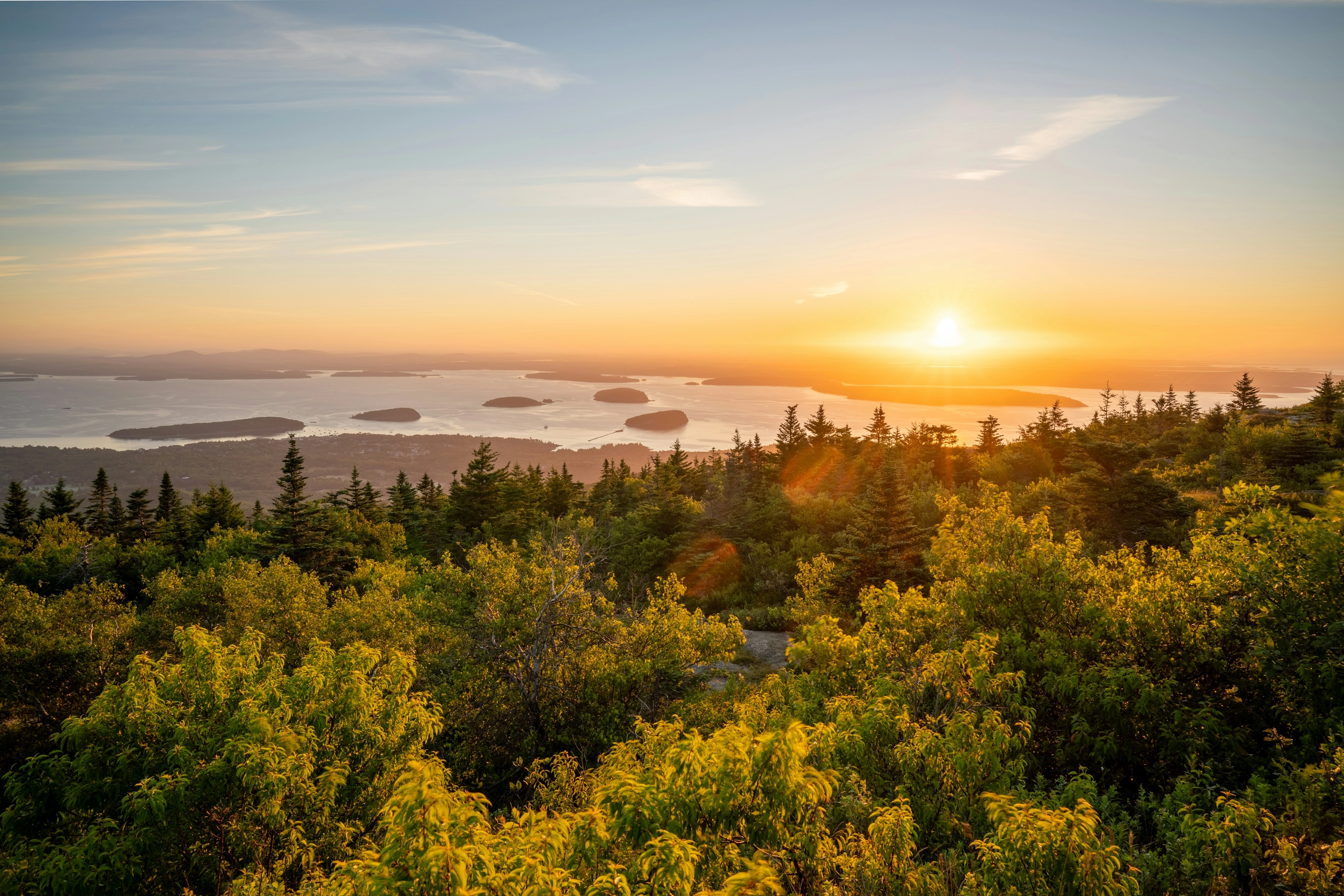
Cadillac Mountain at sunrise
Cadillac Mountain rises to about 465 m according to Wikipedia (DE) and is considered the highest point on the US Atlantic coast according to Wikipedia (EN, ES). This view shows a sunrise over the bay and its wooded islands. To drive to the summit, the National Park Service requires a reservation from late May to mid-October; check the rule for the year.
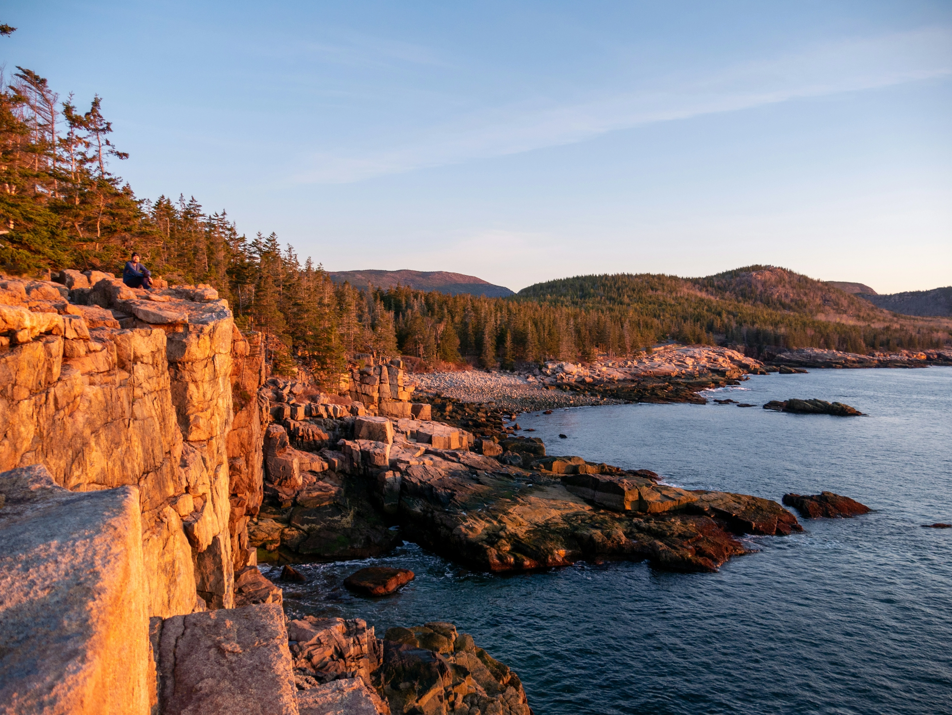
The granite cliffs of the coast
This view shows pink granite cliffs at sunset above a dark sea. Wikivoyage (EN) names Sand Beach, Thunder Hole and Otter Cliffs on the park coast; the loop road is 27 miles (43 km) long according to the National Park Service, which adds that much of it is closed to cars in winter.
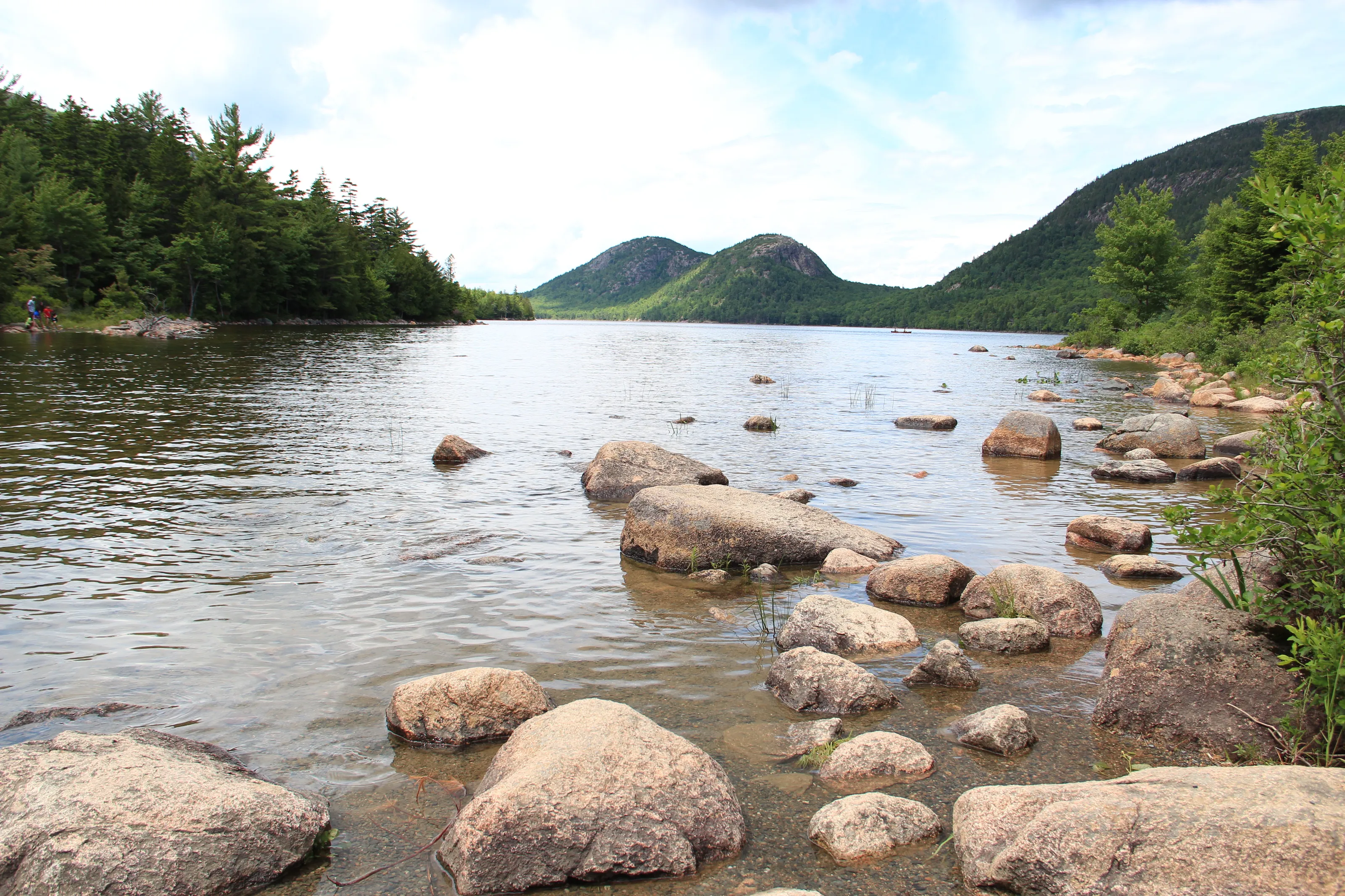
Jordan Pond and the Bubbles
Jordan Pond is the deepest lake in the park, about 150 ft (46 m) according to the National Park Service, which bans swimming because it supplies drinking water. This view shows its granite boulders and two symmetrical hills, the Bubbles. The Bubbles trail is 1.5 miles round trip according to the same site.
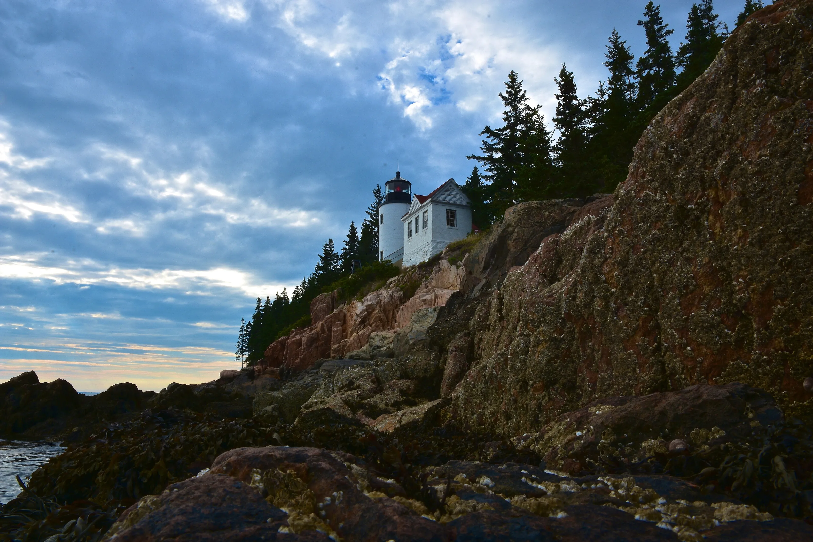
Bass Harbor Head Light
Bass Harbor Head Light, in Tremont, was built in 1858 according to the National Park Service, which calls it the most visited place on the west side of the island, with 180,000 visitors a year. This view shows the white tower perched on the cliff. The interior is closed to the public; the exterior can be seen from a paved path.
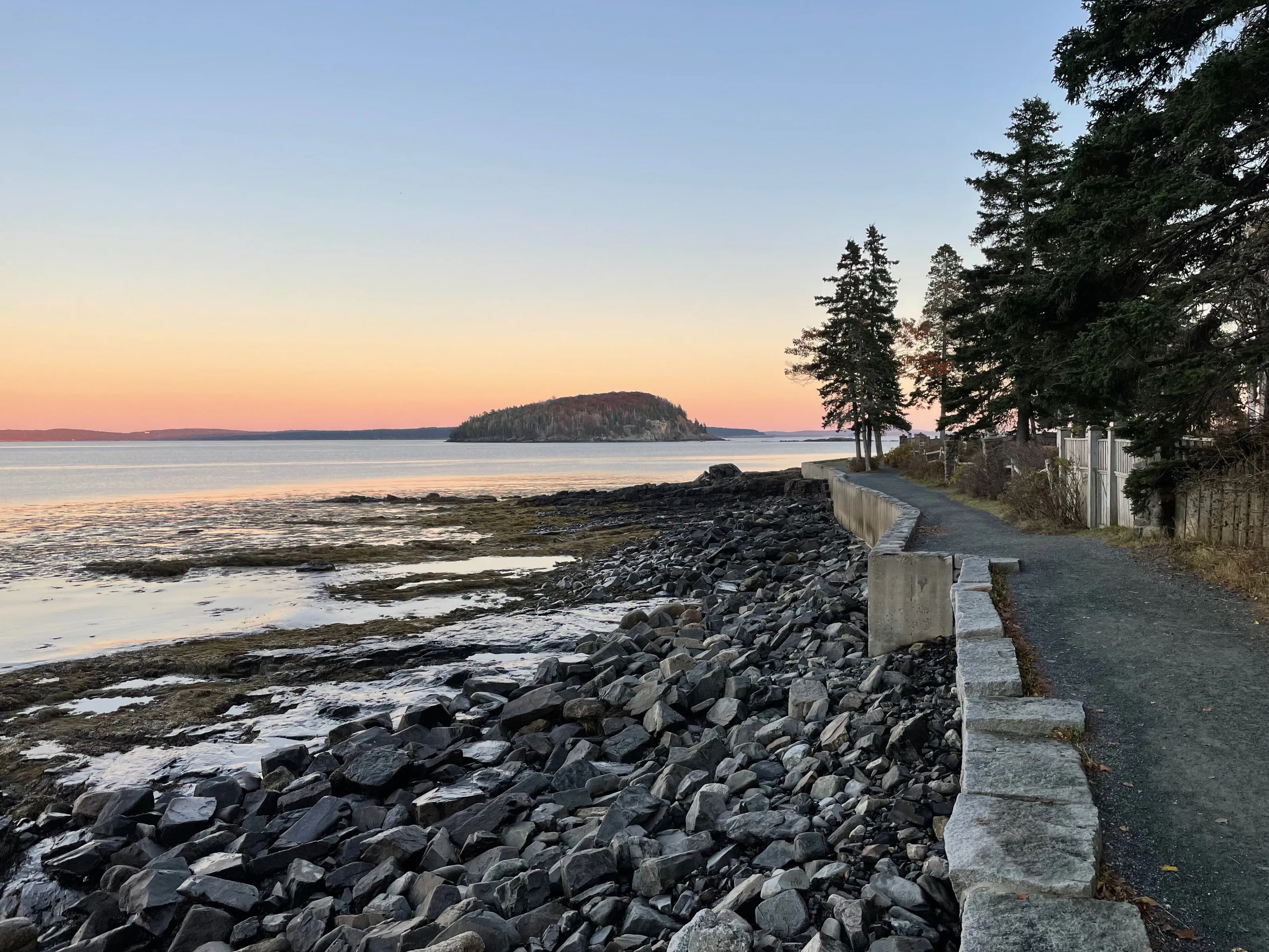
Shore Path and Bar Island
The Shore Path is a coastal path running past private lawns by the sea according to Wikipedia (EN). This view shows it at dusk, with low tide and a wooded island. At low tide a sand bar links the town to Bar Island; it gave the town its name according to Wikipedia (EN, ES). Check tide times before crossing.
Other landmarks named by Wikipedia (EN, FR) and Wikivoyage (EN): the Village Green, the central public park ranked among the great public spaces of the United States in 2012 according to Wikipedia (EN); College of the Atlantic, founded in 1969 according to Wikipedia (FR); and whale and puffin watching boat trips according to Wikipedia (EN).
Museums and culture
Wabanaki history, whales and natural science
Abbe Museum
The museum is devoted to the history and culture of the Wabanaki, the Native peoples of Maine according to Wikipedia (EN, FR). Wikivoyage (EN) also lists it. Hours and fees change: we do not list them.
Bar Harbor Historical Society
Wikivoyage (EN) lists this local history society, with limited winter hours. The fire of 1947, which destroyed 67 cottages and more than 10,000 acres of the park according to Wikipedia (EN), is part of the story it tells.
Whale museum
Wikivoyage (EN) mentions a small whale museum in town. Boat trips to watch whales and puffins are described by Wikipedia (EN) as headline activities.
Dorr Museum of Natural History
This natural history museum belongs to College of the Atlantic according to Wikivoyage (EN), an institution founded in 1969 and devoted to human ecology according to Wikipedia (FR).
Food and drink
Lobster, ice cream and seaside restaurants
Lobster, heart of the local economy
Wikipedia (FR) names lobster fishing among the pillars of the local economy, with tourism. Wikivoyage (EN) mentions seafood restaurants in town; we name no business, because addresses and hours change.
Lobster ice cream
Wikipedia (EN, ES) mentions a lobster ice cream, a local curiosity sold by a chocolate shop in town. It is more a wink than a must.
Tables by budget
Wikivoyage (EN) sorts meals into three tiers: budget (ice cream and chocolate shops, supermarket), mid-range (cafes, pubs) and splurge (fish and seafood). Out of season many places close.
By the bay
The Village Green and the waterfront concentrate restaurants and shops according to Wikivoyage (EN). Boat trips leave from the harbour according to Wikipedia (EN, ES).
Getting around
Free bus, bike, carriage roads and walking
Island Explorer bus
A fare-free seasonal bus, from mid-June to early October, started in 1999 according to Wikipedia (EN). It stops at most trailheads according to Wikivoyage (EN). Bikes ride on the front.
On foot
The centre is small and can be covered on foot according to Wikivoyage (EN). In summer the same guide advises against driving: parking is limited.
Bicycle and carriage roads
The park's carriage roads total 45 miles according to the National Park Service, and are also used for skiing in winter. Bikes can be rented in town according to Wikivoyage (EN).
Car
The park requires a pass year-round according to the National Park Service; the Cadillac Mountain summit road needs a reservation in season. We give no fees.
Budget and precautions
Price level and precautions
Price level
Bar Harbor is a seasonal tourist destination: Wikivoyage (EN) notes wide swings in lodging rates between spring and summer and finds restaurants costly for a tight budget. We give no price range, for lack of a second independent source. The currency is the US dollar (USD).
Flights and alerts
SniperAir tracks prices to BHB and compares them with the route's history, but it does not sell or book tickets. Flights to Bangor (BGR) or Boston (BOS) can be tracked in parallel, followed by a drive or a bus ride.
Precautions
Wind and cool air can surprise you on the coast and the summits, even in summer according to Wikivoyage (EN): plan layers of clothing and water. Part of the park road is closed to cars in winter according to the National Park Service. A limit of 1,000 cruise passengers disembarking per day was voted in 2022 according to Wikipedia (EN, DE).
When to go
A humid continental climate, cool, with mild summers
Winter (December to February)
The mean maximum is close to 0 C in January according to Wikipedia (EN). The park encourages visits from November to April, with ice skating and skiing on the carriage roads according to the National Park Service.
Spring (March to May)
The town wakes up gently: the tourist season resumes. Out of season, many places cut their hours according to Wikivoyage (EN); check openings.
Summer (June to August)
The mean maximum reaches about 26 C in July according to Wikipedia (EN). It is high season: the centre is very busy and cruise ships call from May to October according to Wikipedia (EN, ES).
Autumn (September to November)
A fine season for trails and views, with fewer people than in summer. The town is much quieter between October and April according to Wikivoyage (EN), and many places cut their hours.
The climate is humid continental (Dfb) according to Wikipedia (EN): about 1,440 mm of precipitation a year. Sources differ on snowfall: we publish no figure. To choose your dates, tracking prices to BHB early helps you compare several periods.
By length of stay
What to do in Bar Harbor by length of stay
Centre and bay
One day for the Village Green, the Shore Path, the Abbe Museum and, at low tide, Bar Island.
Acadia
Add the loop road, Sand Beach, Thunder Hole, Jordan Pond and a sunrise on Cadillac Mountain, with the reservation if needed.
West coast and trails
Plan on Bass Harbor Head Light, trails such as the Bubbles and boat trips, with some margin for schedules.
In pictures
Bar Harbor in pictures
You might also like
Similar destinations
FAQ
Frequently asked questions about flights to Bar Harbor
How do I get to Bar Harbor?
By air to BHB, in Trenton, with flights to Boston according to Wikipedia (EN), or via Bangor (BGR) then the road, about 45 minutes to 1 hour according to Wikivoyage (EN).
How far is BHB airport from town?
About 9 miles (15 km) northwest of the centre according to Wikipedia (EN). We do not publish transfer times or fares.
Do I need a car in Bar Harbor?
Not necessarily: the Island Explorer, a fare-free seasonal bus, serves most trailheads according to Wikivoyage (EN). In summer parking is limited.
What is there to see in Bar Harbor and Acadia?
Cadillac Mountain, the loop road, Jordan Pond, Bass Harbor Head Light, the Shore Path and Bar Island at low tide according to the National Park Service and Wikipedia (EN).
Do I need a reservation to drive up Cadillac Mountain?
Yes, from late May to mid-October according to the National Park Service; the rule can change, so check the official site.
When is the best time to go to Bar Harbor?
Summer is high season; the town is much quieter between October and April according to Wikivoyage (EN), while the park encourages off-season visits.
How much does a flight to Bar Harbor usually cost?
The price depends mostly on your departure city, the season and how early you book. The opportunities section above shows real examples of fares SniperAir has already detected to this destination.
How do I get alerted when a flight to Bar Harbor drops below my budget?
Create an alert profile with your departure airport, Bar Harbor as the destination and your maximum budget. You are notified automatically as soon as a matching fare is detected.
Ready to head to Bar Harbor?
Set your budget and let SniperAir monitor fares for you.
Create my alert