
Cheap flights to Martha's Vineyard
Set your departure airport and maximum budget: SniperAir tracks prices to Martha's Vineyard and alerts you the moment a deal matching your criteria appears.
Quick summary
Country
United States
Continent
North America
Airport
MVY
Currency
US dollar (USD)
Time zone
UTC-5 (UTC-4 during summer time)
Deals already spotted to Martha's Vineyard
Real flight examples detected by SniperAir, with their reference price.
Loading examples…
Why track Martha's Vineyard with SniperAir
You don't need to compare prices every day
Choose your departure
Enter your departure airport and your maximum budget for a flight to Martha's Vineyard (MVY).
SniperAir keeps watch
Our systems continuously compare new fares with the route's real price history. SniperAir tracks prices and alerts you: it does not sell or book tickets.
You get an alert
As soon as a fare matches your criteria you are notified, without having searched for anything yourself.
Martha's Vineyard is an island of Massachusetts south of Cape Cod, about 7 miles (11 km) off the coast according to the island's official Chamber of Commerce; Wikipedia (FR, ES) gives slightly shorter distances, between 5.6 and 6 km. The island is about 33 km long and covers more than 230 km2 according to Wikipedia (FR, DE, ES). It has about 20,000 year-round residents according to Wikipedia (EN), which cites a 2023 report; other languages give older, diverging figures. In summer the population is several times larger. SniperAir tracks flight prices to MVY and alerts you; it does not sell or book tickets.
This page is about the island itself, its six towns and how to reach it, not Boston or New York, even though most trips come through one of them. Martha's Vineyard combines colourful clay cliffs at Aquinnah, a fishing village at Menemsha, the white houses of Edgartown and the decorated cottages of Oak Bluffs. You get there through a small airport, MVY, or by boat from Woods Hole on the mainland.
A general reminder: official travel advice differs from one country of departure to another and can change; check your own government's advice before creating an alert and again before any purchase. Visitors from abroad should also check US entry requirements for their nationality. The island is very busy in summer: flights, boats and rooms fill up early.
Airport and getting into town
MVY, the island's airport, and the crossing from Woods Hole
Martha's Vineyard Airport (MVY)
The airport is about 3 miles (4.8 km) south of Vineyard Haven, on the border between West Tisbury and Edgartown according to Wikipedia (EN). It is the only airport on the island served by airlines according to the same source. Wikipedia (EN, ES) mentions year-round links with Boston, Hyannis, Nantucket and New Bedford, and seasonal links with New York, Philadelphia, Washington, Chicago and Charlotte. Carriers and destinations change from season to season: we do not list them.
Approximate distance. We publish neither transfer times nor taxi fares. None of our sources mentions a direct flight from Europe to MVY: most visitors connect through a large US airport, then take a regional flight or a boat.
The sea is the other main way in. From Woods Hole, the crossing to Vineyard Haven takes about 45 minutes year-round according to Wikivoyage (EN) and other sources; Oak Bluffs is served in season. Other departures run from Falmouth, Hyannis, New Bedford (about an hour according to Wikivoyage) and Quonset Point in Rhode Island according to Wikipedia (EN, ES). Only the Woods Hole line carries cars according to Wikipedia (EN) and Wikivoyage (EN), and the booking should be made well ahead. We name no operator and give no fares.
For your alerts, also watch flights to Boston (BOS) or New York, followed by a regional connection or a boat. Boat and flight schedules change with the season: confirm them on the official sites before buying.
Landmarks and sights
Aquinnah cliffs, lighthouses, beaches and Oak Bluffs cottages
Martha's Vineyard is best discovered town by town, between cliffs, harbours and beaches. Five images illustrate the island; other places are described in text.
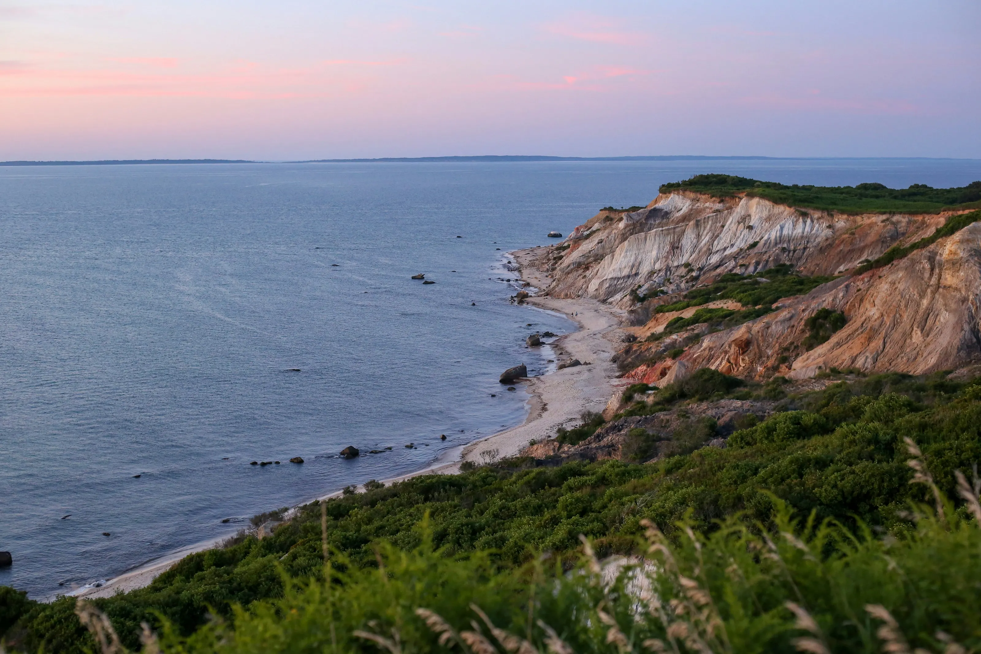
The Aquinnah clay cliffs
Aquinnah, formerly Gay Head, has brightly coloured clay cliffs according to Wikipedia (EN, FR, ES) and Wikivoyage (EN). This view shows them at twilight, above a narrow beach. The Wampanoag still live in Aquinnah, where there is a cultural centre according to Wikipedia (DE).
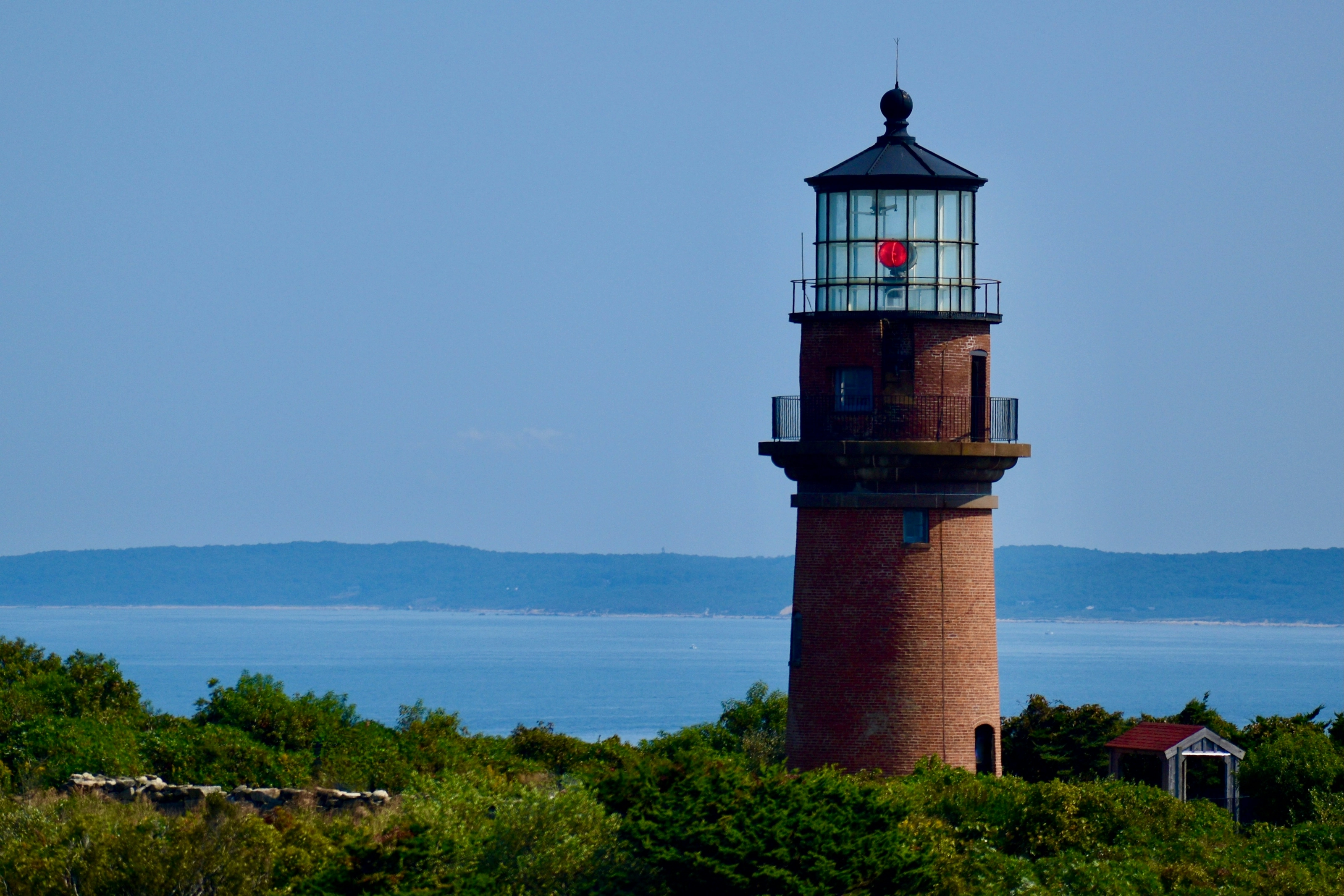
Gay Head Light
Gay Head Light stands above the cliffs according to Wikipedia (EN, ES) and Wikivoyage (EN). This view shows the red-brick tower with its glazed lantern, with the sea and a distant coast behind it.
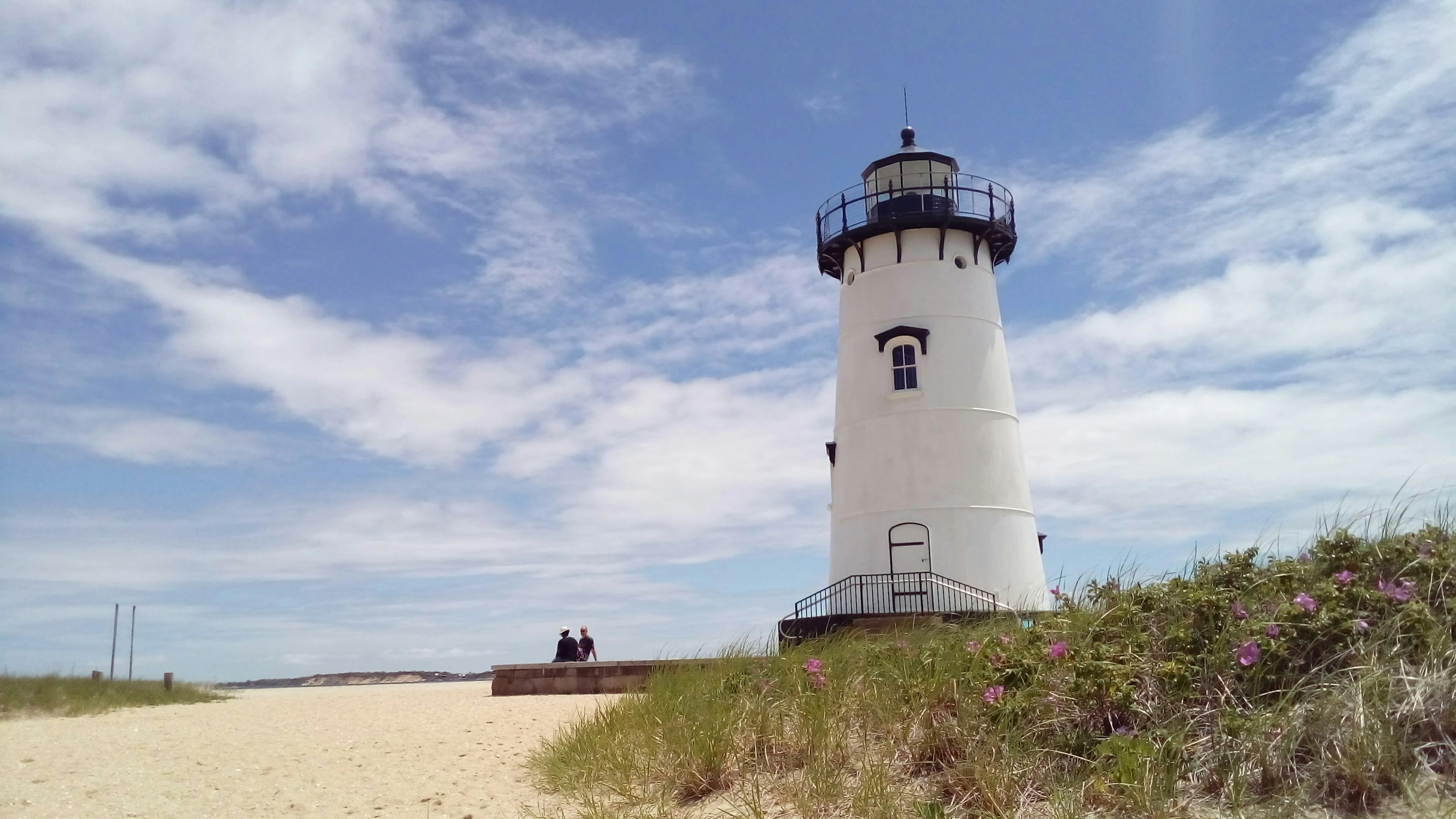
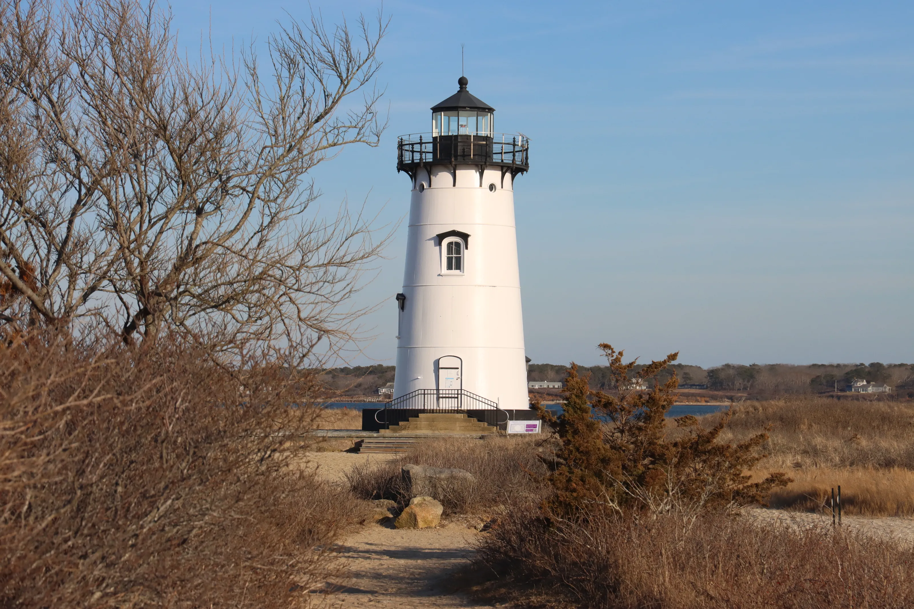
Edgartown Light
Edgartown, the island's main town, is known for its white houses of the 1820s according to Wikipedia (FR) and for its harbour lighthouse according to Wikipedia (EN, FR). This view shows a small white tower with a black lantern on a sandy beach. The Chappaquiddick ferry leaves from town according to Wikivoyage (EN).
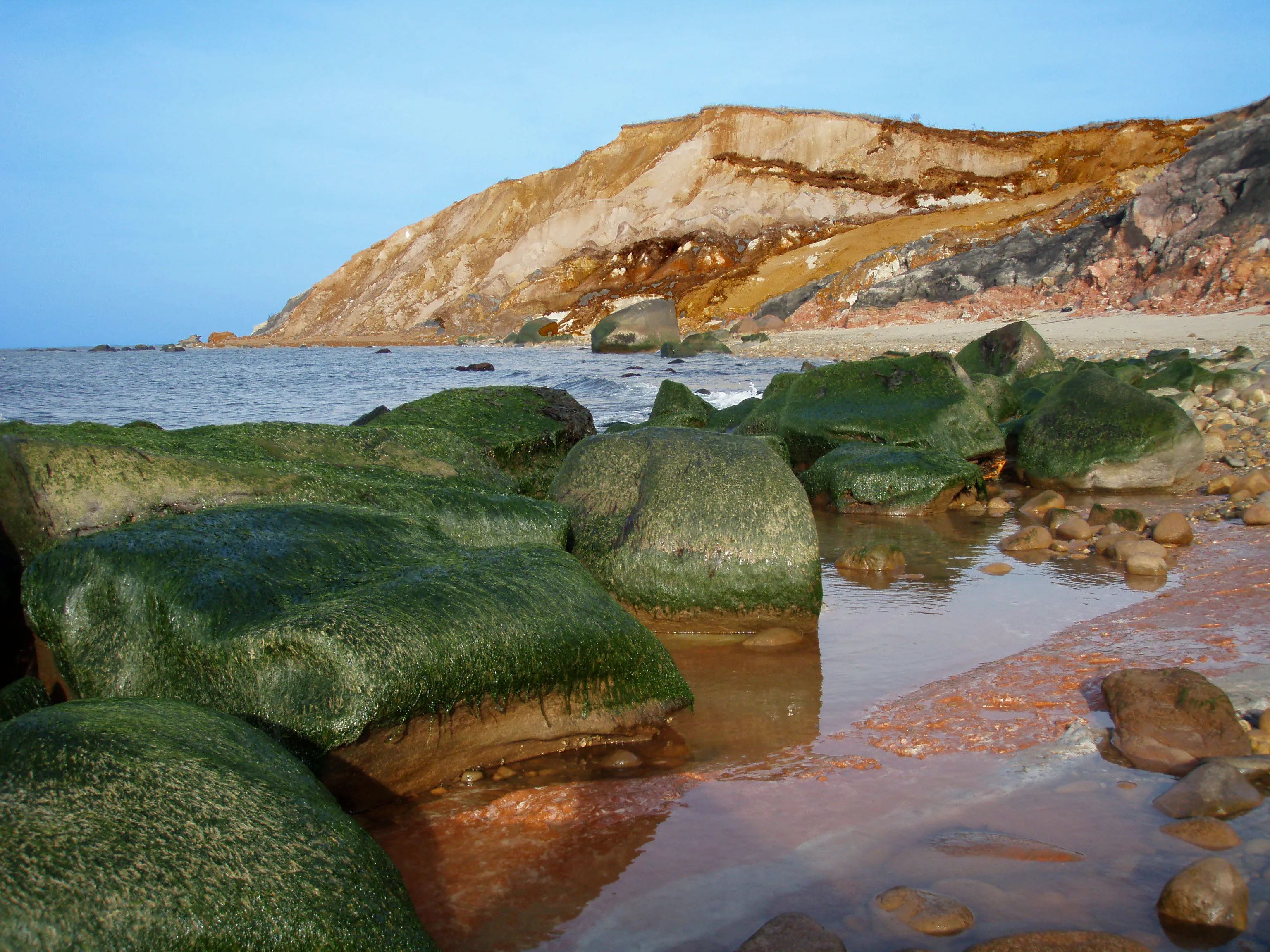
Rocks and beach below the cliffs
At the foot of the Aquinnah cliffs the beach is strewn with large algae-covered rocks, in front of the ochre layers of clay. Wikivoyage (EN) names Moshup Beach among the town's beaches; parking and access may be subject to local rules, so check.
Other places named by Wikivoyage (EN) and Wikipedia (EN): in Oak Bluffs, the gingerbread cottages and the Flying Horses Carousel, described as the oldest operating platform carousel in the United States according to Wikipedia (EN, ES); in Chilmark, the fishing village of Menemsha, known for its sunsets according to Wikivoyage (EN) and the Chamber of Commerce; in West Tisbury, farms and a nature reserve. The film Jaws was shot on the island in 1974 according to Wikipedia (FR, EN, ES).
Museums and culture
Wampanoag history, whaling and historic houses
Martha's Vineyard Museum
The museum is in Vineyard Haven and covers sailing, whaling, Wampanoag history and the lives of islanders according to Wikivoyage (EN). Hours and fees change: we do not list them.
Aquinnah Cultural Center
Wikipedia (DE) names this cultural centre, linked to the Wampanoag community of Aquinnah. The Wampanoag, the first inhabitants of the island they called Noepe according to Wikipedia (FR, DE), numbered about 3,000 in 1642 according to Wikipedia (EN).
Edgartown and its whaling past
The first English settlement was made in 1642 at Great Harbor, now Edgartown according to Wikipedia (EN, ES). The whaling prosperity of the 19th century left white houses and the Old Whaling Church according to Wikipedia (EN).
The Oak Bluffs camp meeting
Oak Bluffs was called Cottage City from 1880 to 1907 according to Wikipedia (EN); the Methodist campmeeting association lies behind the cottage district. We give no count of houses and no visiting hours, for lack of cross-checked sources.
Food and drink
Seafood, farms and island markets
Menemsha and seafood
Menemsha is a fishing village according to Wikivoyage (EN) and the Chamber of Commerce. Restaurants and fish shops in a port like this mostly offer seafood; we name no business, because addresses and hours change.
West Tisbury farms and market
West Tisbury is the island's farming centre according to Wikipedia (ES), with an annual agricultural fair in August, farm stands and a market according to Wikivoyage (EN) and the Chamber of Commerce. It is the place for fruit, vegetables and local produce.
Tables by budget
Wikivoyage (EN) says the island has restaurants 'from casual to fine dining'. Fewer places stay open out of season: check hours.
Oak Bluffs, the lively town
Oak Bluffs is the liveliest town according to the Chamber of Commerce; Wikipedia (ES) mentions its nightlife around Circuit Avenue. Going out is concentrated in summer.
Getting around
Bus, bike, taxi and boats on the island
Island bus
A bus network serves the whole island according to Wikivoyage (EN). We give no fares, which depend on the season and on the pass.
Bicycle
Most roads have a bike path according to Wikivoyage (EN); the west of the island is hillier and windier. Bikes and mopeds can be rented in several towns.
Taxi and car
Wikivoyage (EN) lists several taxi companies. To bring your own car you must reserve the crossing well in advance, because only the Woods Hole line carries vehicles according to Wikipedia (EN).
The Chappaquiddick ferry
A small ferry links Edgartown to Chappaquiddick according to Wikivoyage (EN) and Wikipedia (ES). Wikivoyage (EN) names Cape Poge Lighthouse there.
Budget and precautions
Price level and precautions
Price level
Martha's Vineyard is a resort island: according to Wikipedia (EN), about 56% of homes are occupied seasonally. We give no price range: the fares in our sources are old or rest on a single guide. The currency is the US dollar (USD).
Flights and alerts
SniperAir tracks prices to MVY and compares them with the route's history, but it does not sell or book tickets. Flights to Boston (BOS) or New York can be tracked in parallel, followed by a crossing: the result is sometimes different.
Precautions
Wikivoyage (EN) mentions summer crowds and the possible presence of jellyfish. Museums, restaurants and connections are fewer out of season: check before you come. Beach access rules may vary from town to town.
When to go
An ocean-tempered climate, very busy in summer
Winter (December to February)
Average highs are close to 0 C in January according to Wikipedia (EN); the ocean nevertheless softens winter compared with the mainland according to Wikipedia (DE). The Chamber of Commerce calendar announces 'Christmas in Edgartown' in December.
Spring (March to May)
The season when the island gradually reopens: seasonal links resume and trails can be walked without crowds.
Summer (June to August)
Average highs reach about 22 C in July and August according to Wikipedia (EN), and seldom above 32 C according to Wikipedia (ES). This is high season, the busiest.
Autumn (September to November)
A fine season for lighthouses, cliffs and walks, with fewer people than in midsummer. Services shrink little by little: check openings.
The climate is mostly humid subtropical (Cfa) in the Koppen sense, with an oceanic north according to Wikipedia (EN); rainfall is about 1,190 to 1,210 mm a year. Our sources give no detailed seasonal averages: we publish none. To choose your dates, tracking prices to MVY early helps you compare several periods.
By length of stay
What to do in Martha's Vineyard by length of stay
Edgartown and Oak Bluffs
One day for the harbour, Edgartown Light, the Oak Bluffs cottages and the carousel.
Aquinnah and Menemsha
Add the Gay Head cliffs and lighthouse, the fishing village of Menemsha and a sunset.
Nature and beaches
Plan on Chappaquiddick, the West Tisbury farms, calmer or more exposed beaches and some margin for boat schedules.
In pictures
Martha's Vineyard in pictures
You might also like
Similar destinations

FAQ
Frequently asked questions about flights to Martha's Vineyard
How do I get to Martha's Vineyard?
By air to MVY, with year-round links from Boston, Hyannis, Nantucket and New Bedford according to Wikipedia (EN), or by boat from Woods Hole, about 45 minutes to Vineyard Haven according to Wikivoyage (EN).
How far is the island from the coast?
About 7 miles (11 km) according to the official Chamber of Commerce. Wikipedia (FR, ES) gives slightly shorter distances, between 5.6 and 6 km.
Is MVY airport far from the towns?
It is about 3 miles (4.8 km) south of Vineyard Haven according to Wikipedia (EN). We do not publish transfer times or fares.
Do I need a car on the island?
Not necessarily: a bus network, bike paths and taxis exist according to Wikivoyage (EN). To bring a vehicle, book the Woods Hole crossing early.
What is there to see on Martha's Vineyard?
The Aquinnah cliffs and lighthouse, Edgartown Light, the Oak Bluffs cottages and Menemsha according to Wikipedia (EN) and Wikivoyage (EN).
When is the best time to go to Martha's Vineyard?
Summer is high season, with crowds and possible jellyfish according to Wikivoyage (EN). Spring and autumn are quieter, but services shrink.
How much does a flight to Martha's Vineyard usually cost?
The price depends mostly on your departure city, the season and how early you book. The opportunities section above shows real examples of fares SniperAir has already detected to this destination.
How do I get alerted when a flight to Martha's Vineyard drops below my budget?
Create an alert profile with your departure airport, Martha's Vineyard as the destination and your maximum budget. You are notified automatically as soon as a matching fare is detected.
Ready to head to Martha's Vineyard?
Set your budget and let SniperAir monitor fares for you.
Create my alert