Cheap flights to Tórshavn
Set your departure airport and maximum budget: SniperAir tracks prices to Tórshavn and alerts you the moment a deal matching your criteria appears.
Quick summary
Country
Faroe Islands
Continent
Europe
Airport
FAE
Currency
Faroese króna, on par with the Danish krone (DKK)
Time zone
UTC+0 (UTC+1 in summer time)
Deals already spotted to Tórshavn
Real flight examples detected by SniperAir, with their reference price.
Loading examples…
Why track Tórshavn with SniperAir
A human-scale capital in the middle of the North Atlantic
Choose your departure
Enter your departure airport and maximum budget for a flight to Tórshavn, via Vágar Airport (FAE).
SniperAir keeps watching
Our systems continuously compare new prices with the real price history of the route. SniperAir monitors prices and alerts you: it does not sell or book tickets.
You get an alert
As soon as a price matches your criteria, you are notified without having searched for anything yourself.
Tórshavn is the capital of the Faroe Islands, on the south-eastern coast of Streymoy; the island of Nólsoy shelters the harbour entrance, according to Wikipedia (EN, DE). Its name means "Thor's harbour" (Wikipedia ES). The town has about 14,000 inhabitants, a little over 20,000 including the neighbouring suburbs (Wikipedia EN, DE): a small capital that is very easy to explore on foot. The Tinganes peninsula, its grass-roofed timber houses, the harbour, the Skansin fort and a wooded park all fit within a few kilometres.
This page complements the one on the Faroe Islands as a whole: it focuses on the capital and its surroundings, from Vágar (home of the airport) to Mykines, Kirkjubøur and Nólsoy. The territory is an autonomous part of the Kingdom of Denmark. Flights to the archipelago are few and prices swing with the season, so a SniperAir alert saves you from checking every day: we compare each new price with the real history of the route.
Airport and transfer
Vágar Airport (FAE), the archipelago's gateway
Vágar (FAE)
Vágar Airport, on the island of the same name, is the only airport in the archipelago (Wikipedia EN, FR). It lies about 46 km west of Tórshavn as the crow flies and 47 km by road, according to Wikipedia (EN). Intercity buses cover the trip in about an hour, with roughly ten services a day in each direction (Wikipedia EN); the connection with arrivals is not always well timed, says Wikivoyage (EN). The road goes through the Vágar tunnel, a 4.9 km sub-sea tunnel opened in 2002 and tolled, per Wikipedia (EN).
Distance FAE - Tórshavn: 47 km by road, about one hour by bus (Wikipedia EN, DE). The toll amount and transfer fares are not given here: check them before you travel.
Once there, a rental car lets you roam freely between Vágar, Streymoy and Eysturoy; without a car, public buses and ferries cover the capital and several villages. Fog can delay flights: Wikivoyage (ES) advises building in spare days. Watch FAE for flight prices; Copenhagen (CPH) and Reykjavik (KEF) are two other northern gateways you can track in parallel.
Landmarks and sights
Tinganes, timber lanes and grass roofs
Central Tórshavn can be explored on foot in half a day. The five places below are illustrated; other sights are described further down in text only.
Tinganes, the historic heart
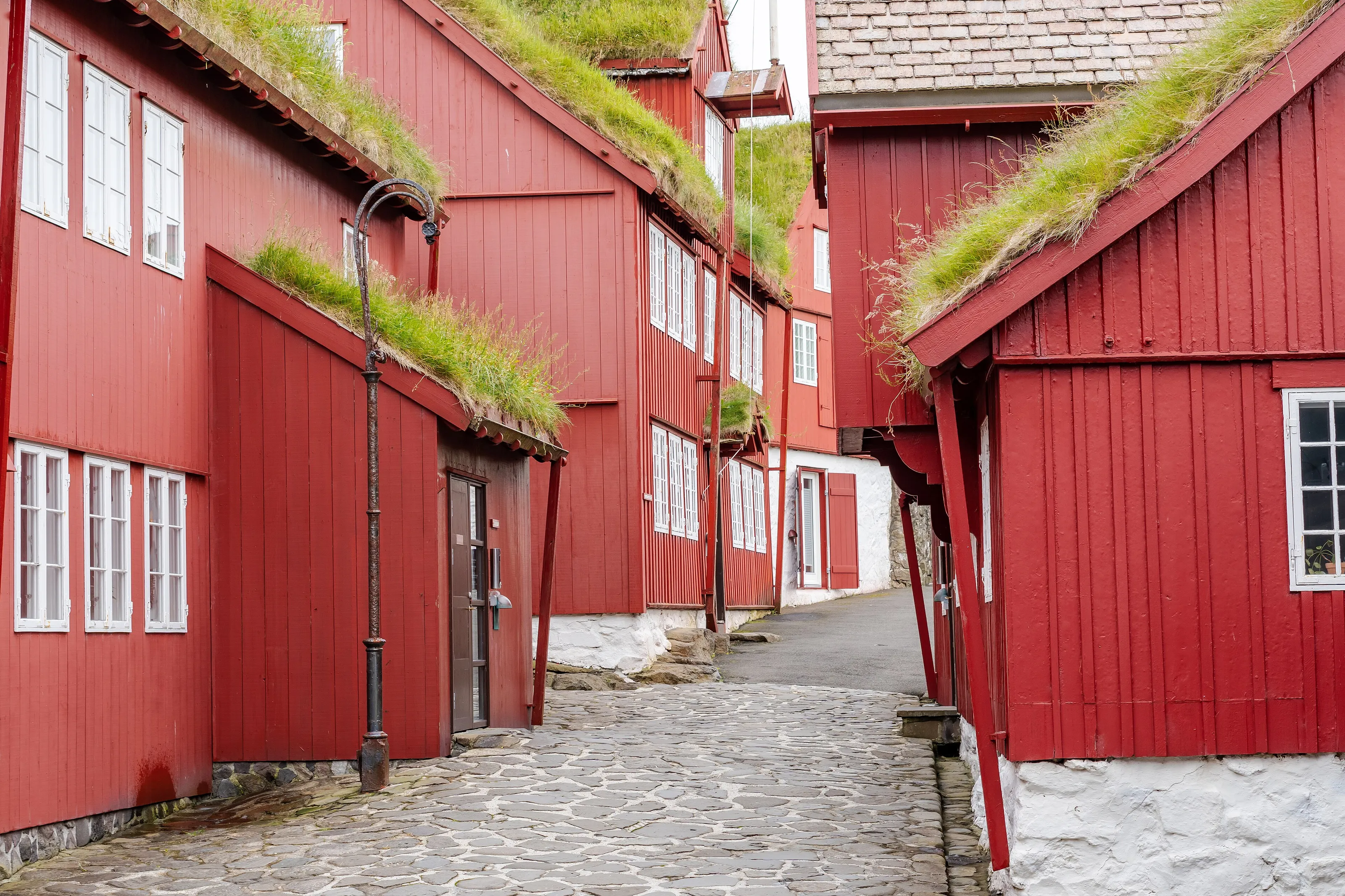
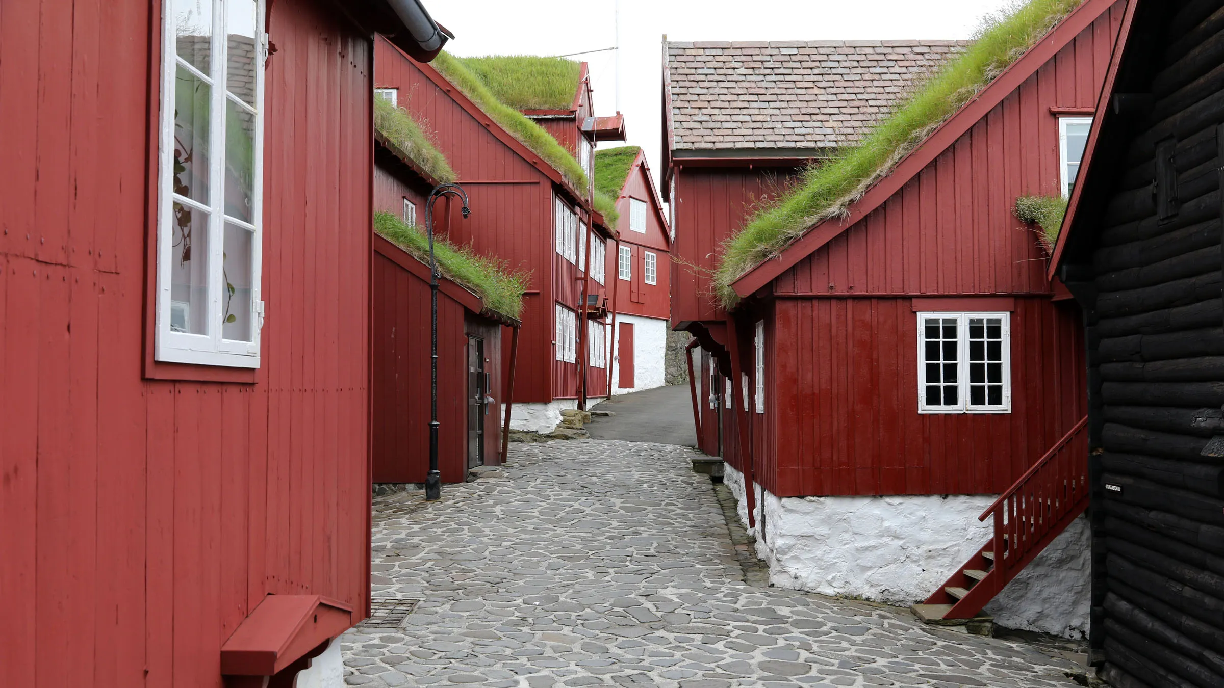
This tongue of rock between two harbours holds the oldest part of town and the seat of the Faroese government, in red timber buildings with grass roofs. The official tourist board calls Tinganes one of the oldest, if not the oldest, parliamentary meeting places in the world; by tradition the thing met here from the 9th century (about 825 per Wikipedia FR, about 850 per Wikipedia EN and DE).
The cobbled lanes of Tinganes
People live and work in these houses: Wikivoyage (EN) asks visitors to respect their privacy. A major fire destroyed part of the quarter in 1673, according to Wikipedia (DE, ES, EN); what you see today comes from later rebuilding.
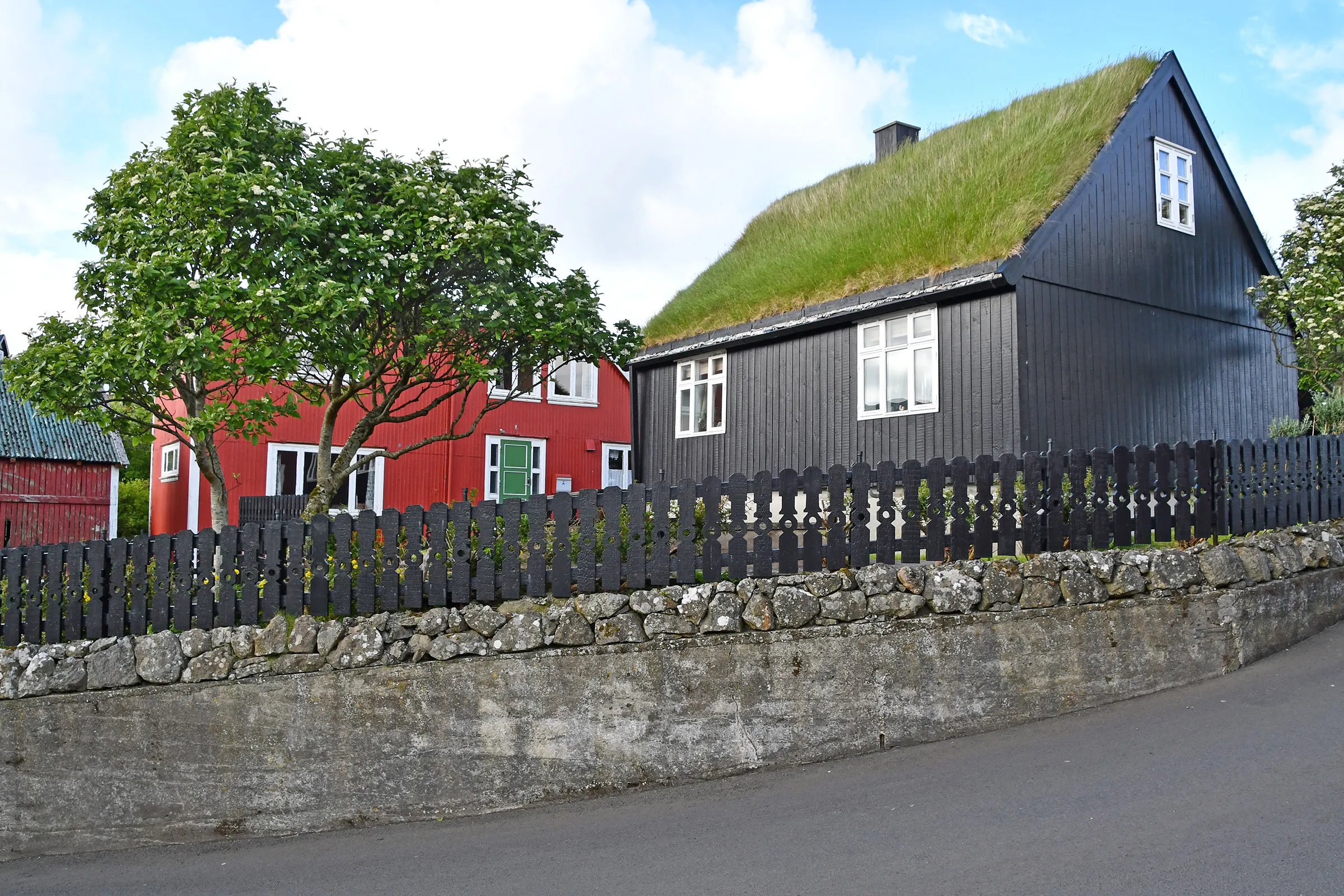
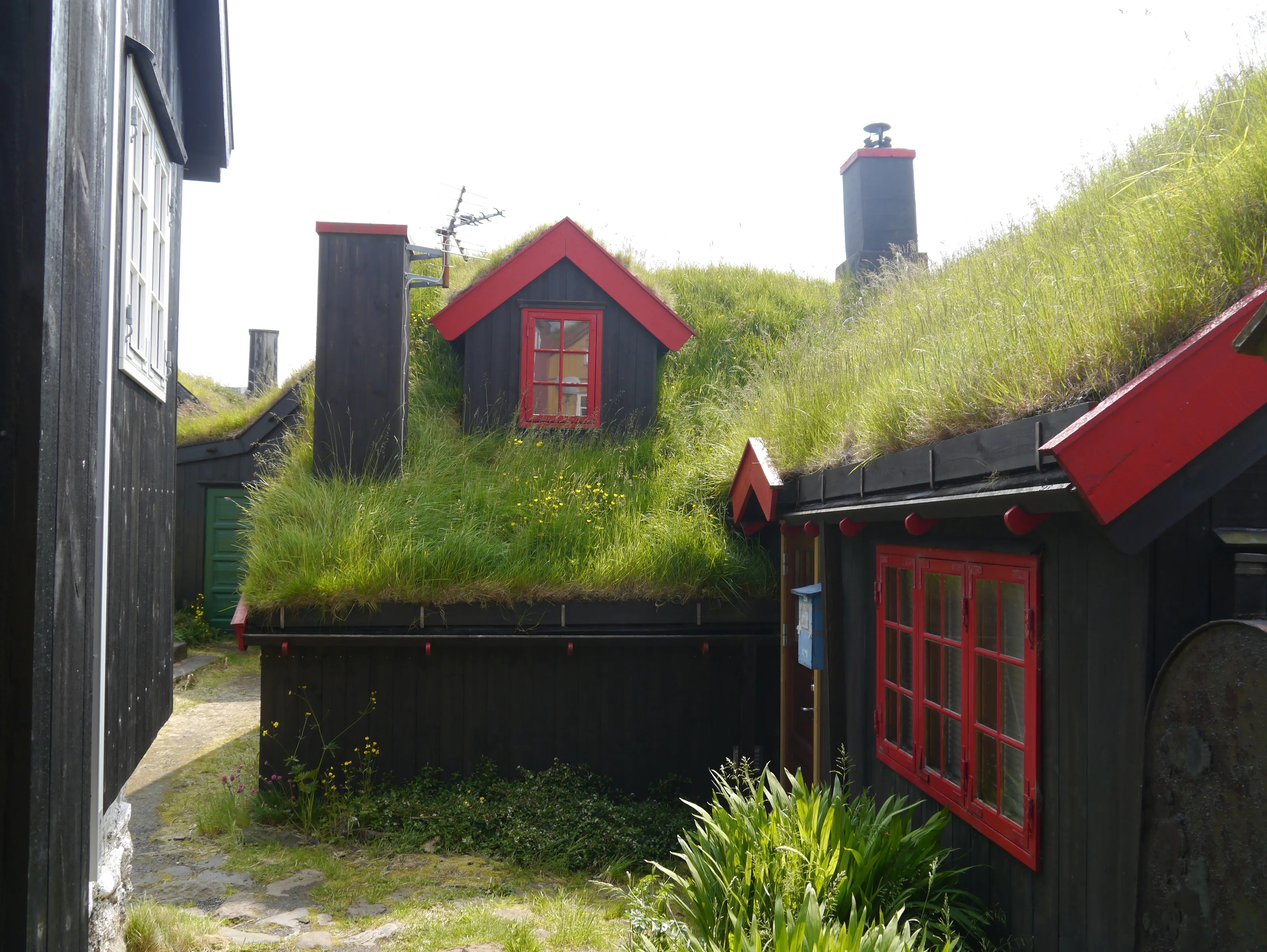
Grass-roofed houses
The grass roof is one of the symbols of traditional Faroese architecture. In the old quarter, black and red houses huddle behind picket fences and low stone walls.
Details of the old quarter
Around each corner, dormers and small-paned windows are often framed in red, and wild flowers grow on the roofs in early summer. This is a district to wander slowly, camera in hand.
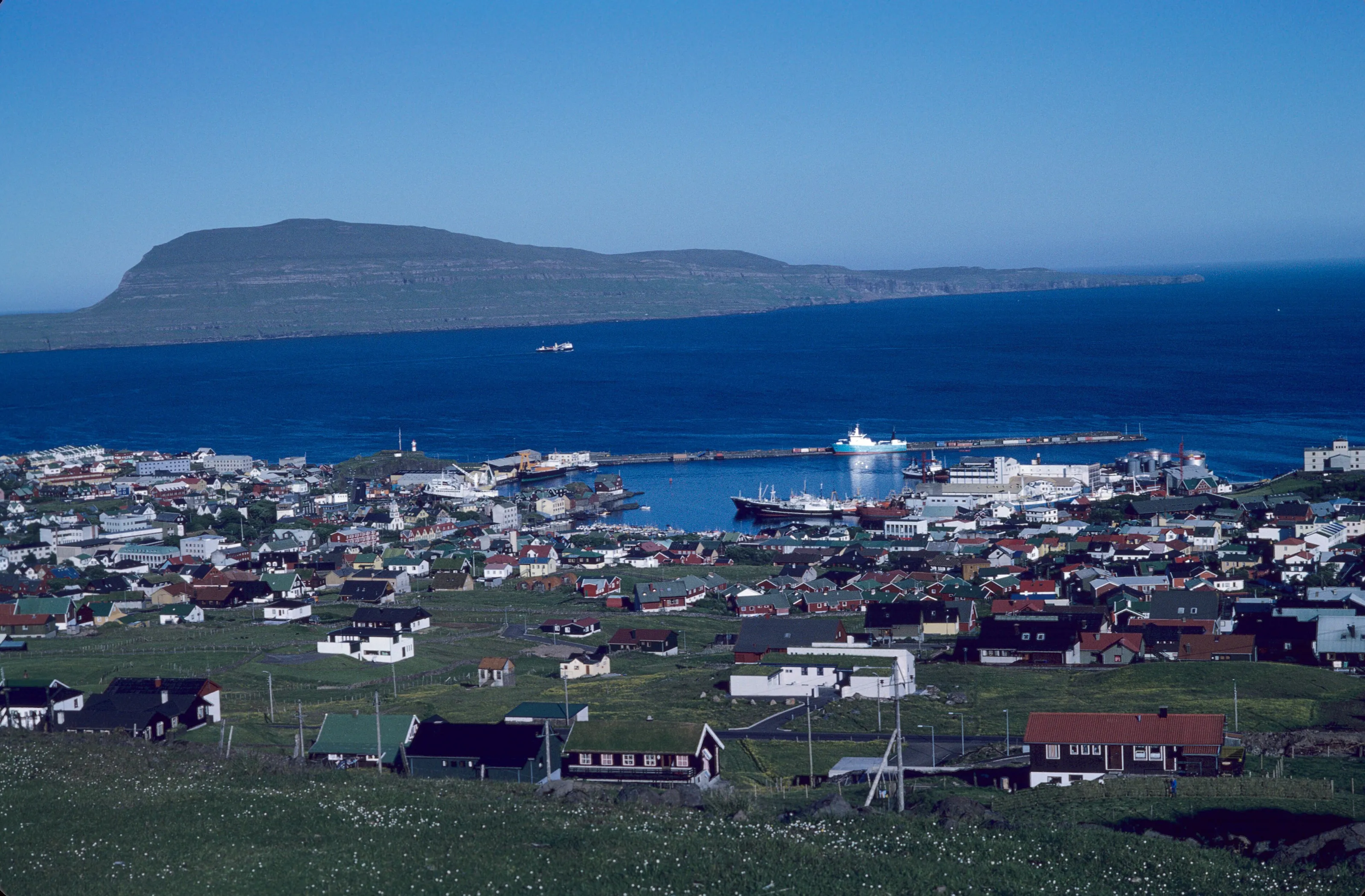
The harbour and town from above
From above, Tórshavn spreads around its natural harbour, with Nólsoy opposite, shielding it from the open sea (Wikipedia DE). The town grew around maritime trade: a Norwegian crown trade monopoly from 1271, free trade in 1856 and a modern harbour from 1927 (Wikipedia FR, DE, EN).
Among the sights without a photo: the Skansin fort, built around 1580 to protect the town from raids, has views over the harbour and Nólsoy and is a good picnic spot; it was the British Royal Navy headquarters in the Second World War (Wikipedia EN, DE). The white cathedral (Havnar Kirkja) with its clock tower dates from 1788 according to Wikivoyage (EN, DE) and was completely rebuilt in 1865 per the tourist board. Viðarlundin park, with its pond, paths and sculptures, is one of the largest in the archipelago. Finally, the national day Ólavsøka is held on 28 and 29 July, with traditional boat races in the harbour (Wikipedia FR, DE).
Museums and culture
Faroese art, history and the Nordic House
Listasavn Føroya, the art museum
Founded in 1989, it holds over 2,000 works, mostly Faroese paintings, prints, sculptures and textiles; its permanent exhibition focuses on landscape and nature, according to the tourist board. Check opening hours before you go.
The National Museum in Hoyvík
North of the town, it covers Faroese geology, history and society and shares a site with an open-air museum of traditional houses, according to Wikivoyage (EN, DE). Wikipedia (EN) also mentions a natural history museum with a botanical garden.
The Nordic House (Norðurlandahúsið)
This cultural centre, built in 1983 and topped with a grass roof, hosts concerts, exhibitions and meetings, and has a cafe (Wikipedia DE; tourist board). Wikivoyage (EN) calls it the main cultural institution in the islands.
Galleries and music
Wikivoyage (EN) mentions a Faroese music gallery with free live concerts on weekdays in summer; times change from season to season, so ask locally.
Food and drink
Dried lamb, fresh fish and local beers
Local specialities
Mutton and fish dominate. Skerpikjøt is wind-dried, well-aged mutton, ræst kjøt is semi-dried mutton and ræstur fiskur is matured fish; they are prepared in the hjallur, the slatted drying shed found at many homes (Wikipedia EN, Faroese cuisine). Pilot whale meat is also part of traditional cooking but is debated abroad; it is entirely optional for visitors.
Restaurants and districts
The town holds most of the archipelago's dining scene: Wikivoyage (ES) notes that outside Tórshavn the choice is limited. The Vestaravág harbour area groups cafes and restaurants; book ahead in high season. The archipelago's starred tables change address, so we do not name them.
Beer and spirits
The islands have several breweries, one brewing since 1888 and another since 2010 (Wikipedia EN). Strong beer and spirits are sold only in state shops or licensed venues (Wikipedia DE, Wikivoyage ES).
Getting around
On foot, by bus, ferry or car
On foot
The centre, the harbour, Tinganes and Skansin are minutes apart. Niels Finsens gøta is the only pedestrian street in town (Wikipedia EN).
City buses
The red-liveried city network covers most of the town; several sources say it has been free since 2007, but conditions for non-residents may have changed, so check on site. Intercity buses reach villages, Klaksvík and the airport.
Ferry and helicopter
A ferry links Tórshavn to Nólsoy in about 20 minutes (Wikipedia EN, ES); longer links go to other islands. Helicopters serve remote islands from the town (Wikipedia DE). Schedules vary and are not detailed here.
Car
In Tórshavn, central parking is time-limited and uses a parking disc (Wikivoyage ES). Sub-sea tunnels have brought the main islands closer; some are tolled.
Around Tórshavn
Vágar, Mykines, Kirkjubøur and Nólsoy
Vágar and Sørvágur
The third-largest island of the archipelago, with about 178 km2 and nearly 3,500 inhabitants (Wikipedia FR). The village of Sørvágur, about 2 km from the airport, is where the boat to Mykines departs (Wikivoyage EN).
Gásadalur and Múlafossur
This village of a few residents (16 in 2025 per Wikipedia EN) could be reached by car only after a tunnel was blasted through in 2004. The viewpoint looks over the houses, a waterfall and the island of Mykines (Wikivoyage EN), best late in the day.
Mykines
The westernmost inhabited island, with 10.3 km2 and a handful of permanent residents, has a Mykineshólmur lighthouse inaugurated in 1909 and linked to the island by a footbridge (Wikipedia FR, DE, EN). Puffins arrive around the end of April according to Wikipedia (DE). The boat from Sørvágur runs only in summer, the helicopter all year; swell or fog can cut the island off (Wikipedia FR, DE). Access to the puffin colony is subject to a fee (Wikipedia EN).
Kirkjubøur and Nólsoy
At Kirkjubøur, St Olaf's Church (12th century) is the oldest still in use in the Faroes, and the ruins of St Magnus Cathedral date from about 1300 (Wikipedia EN). Nólsoy, 4 km east of the capital, hosts one of the world's largest colonies of European storm petrels, about 50,000 pairs per Wikipedia (EN).
Budget and precautions
An expensive archipelago, weather to respect
Price level
The Faroes are an expensive archipelago: Wikivoyage (ES) notes costly public transport. We publish no price ranges because no figures are confirmed by two independent sources; check official sites before booking.
Formalities and currency
The territory is autonomous within the Kingdom of Denmark and is not part of the European Union; entry formalities depend on your country of departure, so check them with your own authorities. The currency is the Faroese króna, on par with the Danish krone.
Weather and safety
The weather can change within hours, with wind, rain and fog (Wikivoyage ES). Crime is not a notable problem according to Wikivoyage (DE). Stay on marked trails, check forecasts before each outing and keep some slack for flight connections.
When to go
A mild but grey oceanic climate; May to September for walking
Spring
Cool and changeable; days lengthen fast, and May is the sunniest month according to Wikipedia (EN). Puffins return to Mykines around the end of April.
Summer
Daytime highs of about 13 °C in July and August per Wikipedia (EN), very short nights and the Ólavsøka festival at the end of July. This is the busiest season and the one with the highest accommodation prices.
Autumn
Days shorten and rain and wind settle in; check connections to remote islands.
Winter
Mild for the latitude, with an average January high of about 6 °C, but dark and windy. Check opening hours of tourist services.
Tórshavn has a subpolar oceanic climate: about 1,400 mm of rain a year and roughly 1,000 hours of sunshine, according to the 1991-2020 normals in Wikipedia (EN, FR). Fog is frequent. For walking and long days, aim for May to September, the tourist season given by Wikivoyage (ES).
By length of stay
How many days to spend in Tórshavn
The capital
Tinganes, the harbour, Skansin, a museum and a cafe are enough for a first visit.
Capital and Vágar
Add Kirkjubøur, Nólsoy or a drive to Vágar with Gásadalur and the Múlafossur waterfall.
Mykines and the northern islands
With five days, plan for Mykines, weather and connections permitting, then the islands linked by tunnel.
In pictures
Tórshavn in pictures
You might also like
Similar destinations
FAQ
Frequently asked questions about flights to Tórshavn
Which airport do I fly into for Tórshavn?
Vágar Airport (FAE), the only airport in the archipelago, is about 47 km from Tórshavn by road. A bus links the two in about an hour, with around ten services a day in each direction according to Wikipedia (EN).
How do I get from Vágar Airport to Tórshavn?
By intercity bus in about an hour, by rental car or by a shuttle booked in advance. The road goes through a 4.9 km sub-sea tunnel, which is tolled. The bus connection with arrivals is not always ideal: check the timetable.
What is there to see in Tórshavn?
The Tinganes peninsula and its grass-roofed houses, the Skansin fort, the cathedral, the Nordic House, the art museum, the National Museum in Hoyvík and Viðarlundin park.
Can I visit Mykines from Tórshavn?
Yes, but usually by starting from Vágar: a boat links Sørvágur to the island in summer, and a helicopter serves Mykines all year. Fog or swell can cut access, so leave some slack.
Is Tórshavn expensive?
Yes, the archipelago is expensive, notably for public transport, meals and summer accommodation. We do not publish price ranges because figures are not confirmed by cross-checked sources.
When is the best time to visit Tórshavn?
May to September for walking and long days. Winter is mild for the latitude but dark and windy, and the oceanic climate is rainy and misty all year.
How many days should I plan in Tórshavn?
One day for the capital, three with Kirkjubøur, Nólsoy and Vágar, five or more with Mykines and the northern islands.
How do I get alerted when a flight to Tórshavn drops below my budget?
Create an alert profile with your departure airport, Vágar (FAE) as destination and your maximum budget. You are notified as soon as a matching price is detected. SniperAir monitors and alerts; it does not sell or book tickets.
Ready to head to Tórshavn?
Set your budget and let SniperAir monitor fares for you.
Create my alert