

Cheap flights to St. John's
Set your departure airport and maximum budget: SniperAir tracks prices to St. John's and alerts you the moment a deal matching your criteria appears.
Quick summary
Country
Canada
Continent
North America
Airport
YYT
Currency
Canadian dollar (CAD)
Time zone
UTC-3:30 in winter, UTC-2:30 in summer (Newfoundland time)
Deals already spotted to St. John's
Real flight examples detected by SniperAir, with their reference price.
Loading examples…
Why track St. John's with SniperAir
You do not need to compare prices every day
Choose your departure
Enter your departure airport and your maximum budget for a flight to St. John's (YYT).
SniperAir keeps watch
Our systems continuously compare new prices with the real price history of the route. SniperAir monitors prices and alerts you: it does not sell or book tickets.
You receive an alert
As soon as a price matches your criteria, you are notified, without having searched for anything yourself.
Airport and getting into town
St. John's airport, close to downtown, at the eastern edge of the continent
St. John's International Airport (YYT)
YYT is, according to Wikivoyage (FR), the easternmost airport in North America. It lies about 10 km (6.2 miles) from downtown according to Wikivoyage (EN) and ten minutes to the northeast according to Wikipedia (DE); Wikipedia (FR) says 6 km to the northwest, so sources differ. Direct flights link it with Toronto (about 3 hours), Montreal (about 2.5 hours) and Halifax (about 1 h 45) according to Wikivoyage (EN). A bus serves downtown on weekdays, but a taxi or a rental car is simpler. From Nova Scotia you can also arrive by ferry (Wikivoyage FR, EN).
Distances and times are approximate, based on Wikivoyage, Wikipedia and official sites; timetables change, so check them before you travel. We do not quote fares.
St. John's is the capital and largest city of Newfoundland and Labrador, on the Avalon Peninsula facing the Atlantic (Wikivoyage FR). The city has about 110,000 residents (Wikipedia DE) and more than 200,000 in its metropolitan area (Wikivoyage EN, Wikipedia FR). It lies about 2,100 km (1,339 miles) northeast of Toronto, closer to Dublin than to Vancouver (Wikivoyage EN, ES), and is the easternmost point of the Trans-Canada Highway. It appears on a Portuguese map of 1519, one of the oldest European settlements in the New World (Wikipedia FR).
Landmarks
Colourful houses, Signal Hill, Cape Spear and a harbour under the cliffs
St. John's is a city of harbour, cliffs and brightly painted wooden houses climbing from a natural haven (Wikivoyage EN). The places below are illustrated; Signal Hill, Fort Amherst and The Battery are described in text.
Colourful houses at the foot of the hills
At the water's edge, small colourful wooden houses cluster at the foot of a rocky hill. Wikivoyage (EN) describes multicoloured terraces climbing from a snug natural harbour sheltered by steep-sided cliffs. In the background, a stone tower crowns the hill.
The harbour and the Narrows
St. John's harbour is sheltered from the Atlantic's worst excesses by steep-sided cliffs and a narrow entrance called the Narrows (Wikivoyage EN). It can be viewed from Signal Hill or the eastern shore. The city grew around this haven, a maritime gateway to North America.

Jellybean Row
The steep streets of the old town are lined with rows of brightly painted houses, hence the nickname Jelly Bean Row. The bright colours date from the 1970s, when coal soot no longer darkened façades (Wikipedia EN). Fog is frequent: Wikipedia (EN) counts 124 foggy days a year.

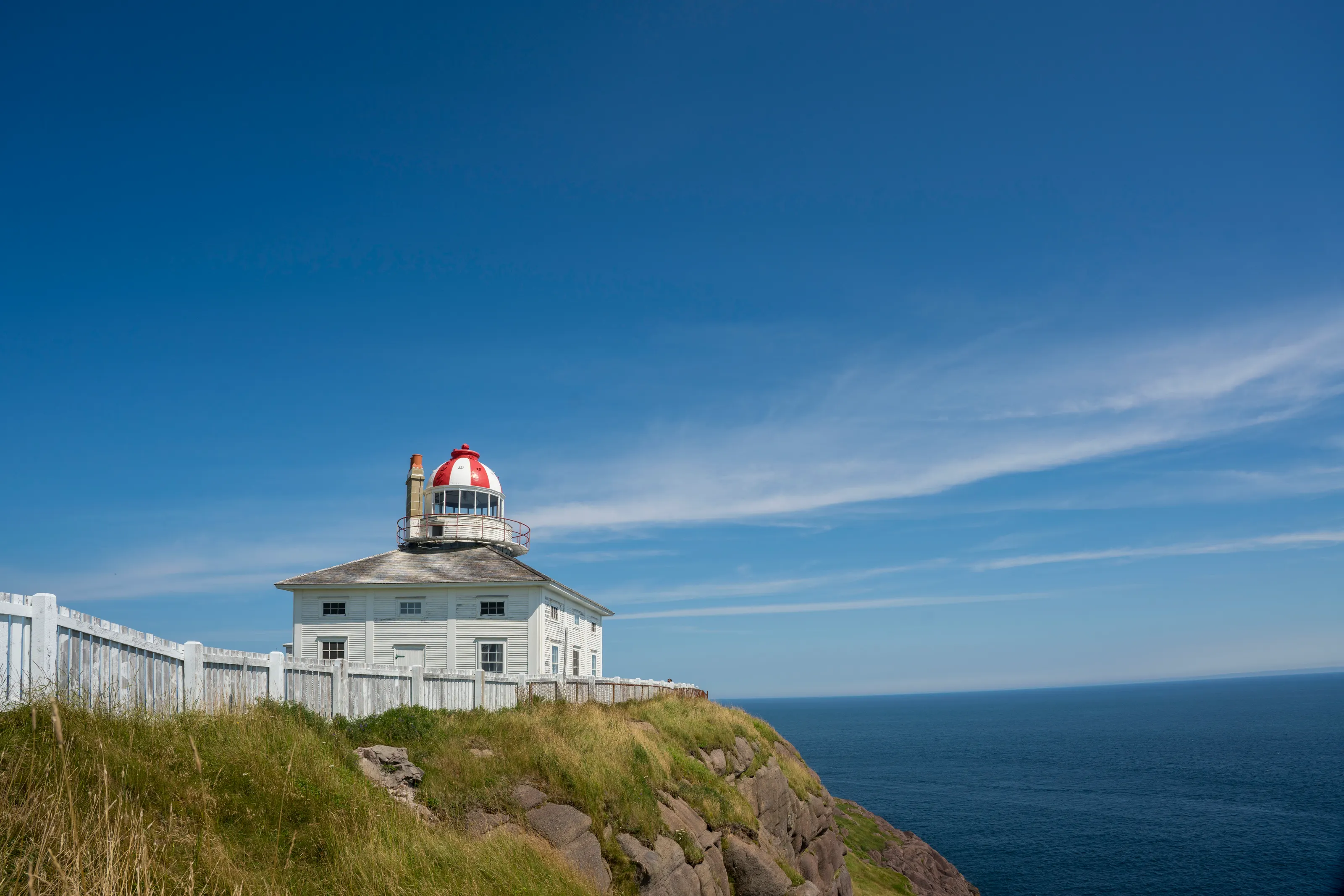
Cape Spear
Cape Spear, about 15 km from downtown, is the easternmost point in North America apart from Greenland (Wikivoyage EN). An active lighthouse and an old lighthouse with a museum stand there (Wikivoyage DE). A summer hop-on hop-off bus links downtown, Quidi Vidi, Cape Spear and Signal Hill (Wikivoyage EN).
Quidi Vidi
The fishing village of Quidi Vidi, a few kilometres from downtown, has a harbour, wooden wharves and a brewery (Wikivoyage DE). Quidi Vidi Lake, the harbour and Signal Hill are within walking distance of downtown according to Wikivoyage (EN).

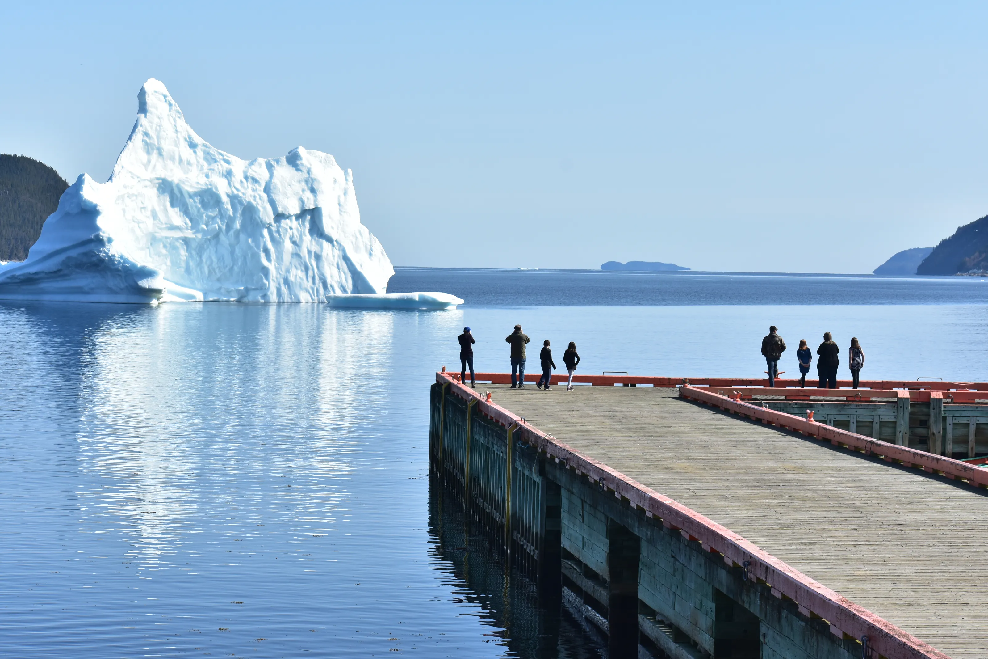
Icebergs
Icebergs from the north drift near the coast in the melting season and can be seen when there is no fog (Wikipedia FR, Wikivoyage FR). Wikivoyage (EN) advises April and May to see them; boat tours also offer whale and seabird watching.
Signal Hill, Fort Amherst and The Battery
Signal Hill, a National Historic Site of Canada, overlooks the city; Cabot Tower, built in 1897, crowns the hill, and the first transatlantic wireless message was received there in 1901 according to Wikivoyage (EN, FR). Fort Amherst, with its lighthouse and Second World War fortifications, stands across the Narrows from Signal Hill. The Battery, a village of small houses framed by cliffs, once helped defend the harbour (Wikivoyage EN).
Museums and culture
The Rooms, Johnson Geo Centre and Railway Coastal Museum
The Rooms
The Rooms combines the provincial museum, the archives and the art gallery of Newfoundland and Labrador in a building that has become a landmark, with wide views from the upper floor (Wikivoyage EN, Wikipedia EN). We do not quote admission prices.
Geology and railways
The Johnson Geo Centre, on the slopes of Signal Hill, interprets the region's geology, and the Railway Coastal Museum occupies the old station on Water Street (Wikipedia EN).
History and music
The city was the capital of a colony and then a dominion before becoming a provincial capital in 1949 (Wikivoyage EN). The taverns of George Street and Water Street give pride of place to traditional music, including fiddle (Wikivoyage EN).
Food and drink
Fried fish, cod cheeks and Irish pubs
Newfoundland specialties
Among local dishes, Wikivoyage (EN) lists fries with dressing and gravy, fish-and-brewis, made with hard bread, and cod cheeks. Fish and chips hold a big place, with several well-known addresses in town.
Pubs and beer
George Street and Water Street concentrate pubs, many of them Irish, which is no surprise since St. John's is the North American city closest to Ireland (Wikivoyage EN). Cold beer is sold in convenience stores, but wine and spirits only in provincial liquor stores.
Cafés and brunch
Local cafés and bakeries serve breakfast and soups all day; vegetarian cooking and other world cuisines are also represented (Wikivoyage EN, ES).
Getting around
Limited transport: rely on a car and your legs
Metrobus
The Metrobus network serves almost the whole city, but buses are often early or late and locals do not consider them reliable. Stops are not cleared of snow in winter (Wikivoyage EN). We do not publish fares.
On foot
For trips under 4 km, walking is often faster than the bus according to Wikivoyage (EN). Quidi Vidi Lake, Quidi Vidi and Signal Hill are within walking distance of downtown; in winter, sidewalks and stops can be snowbound.
Rental car
St. John's is a driver-dominated city with a haphazard road layout: a map or GPS is essential (Wikivoyage EN). A car remains the best way to discover the Avalon Peninsula, Cape Spear, Bay Bulls and fishing villages. Outside the city, neighbouring communities have no bus service.
Budget and precautions
A mid-range price level, and weather to plan for
Price level
St. John's sits in a mid-range bracket for Canada; boat tours and a rental car weigh more than meals. The currency is the Canadian dollar. We do not publish figures: sources are dated or disagree.
Flights and alerts
SniperAir tracks flight prices to YYT and compares them with the route's history, but it does not sell or book tickets. The island is far away: direct flights come from Toronto, Montreal, Halifax and a few seasonal destinations.
Safety and weather
The city is generally safe; Wikivoyage (EN) advises care on George Street on weekend nights at bar closing time. Fog, wind and rain are frequent: pack waterproof clothes in layers. Visitors from abroad should check Canada's entry requirements for their nationality.
When to go
Cool, foggy summers and snowy, windy winters
Harsh winter (December to March)
Cold, damp and windy: February mean about -5 °C (-4.7 °C or 23.5 °F according to Wikipedia EN), heavy snowfall, between 243 and 322 cm a season depending on the source (Wikipedia EN, ES). Days are short, from 7:45 to 16:15 (Wikivoyage EN).
Spring (April to June)
Cool and foggy. April and May are the best months to see icebergs according to Wikivoyage (EN).
Summer (July to August)
Cool: average highs around 21 °C (70 °F) and lows of 13 °C (55 °F) (Wikivoyage EN). Whale and seabird watching peaks from mid-June to mid-August; the Royal Regatta takes place in early August (Wikipedia ES).
Autumn (September to November)
Rainy and windy: the wettest months run from October to January according to Wikipedia (EN), and tropical cyclones can threaten the city in late summer (Wikivoyage EN).
St. John's has a cold, humid temperate climate (Dfb) according to Wikipedia (FR), strongly shaped by the ocean and the cold Labrador Current, which makes temperatures 7 to 8 °C lower than in a French city at the same latitude. Wikipedia (EN) counts about 1,539 mm of precipitation a year and 124 foggy days. The best time for the city runs from June to August, unless you are looking for icebergs: aim for April and May.
By length of stay
What to do in St. John's depending on your length of stay
The essentials
The colourful downtown houses, Signal Hill, the harbour, George Street and a sunset over the cliffs.
Coasts and villages
Cape Spear, Quidi Vidi, a boat trip for whales and icebergs from the harbour, The Rooms.
Avalon Peninsula
Bay Bulls about 32 km (20 miles) east for sea excursions, the Irish Loop (7 to 8 hours of scenic driving) or Bonavista about 310 km (190 miles) north, with a rental car.
In pictures
St. John's in pictures
You might also like
Similar destinations


FAQ
Frequently asked questions about flights to St. John's
How do I get from St. John's airport to downtown?
YYT is about 10 km from downtown depending on the source. A taxi or rental car is simplest; a bus also serves downtown on weekdays. Check timetables before you travel.
When can I see icebergs in St. John's?
April and May are recommended by Wikivoyage. There must be no fog; a boat tour lets you see them better.
When can I see whales?
From mid-June to mid-August, at the peak of whale and seabird watching, from nearby ports such as Bay Bulls.
Do I need a rental car?
Yes, it is recommended: public transport is limited and not very reliable, and the Avalon Peninsula is large. Downtown can be covered on foot.
Why are the houses so colourful?
The bright colours date from the 1970s, when coal, which blackened façades, stopped being used according to Wikipedia (EN).
What is the weather like in St. John's?
Cool and damp, with fog, wind and plenty of snow in winter. Summer is the most pleasant season.
How much does a flight to St. John's usually cost?
The price depends mainly on your departure city, the time of year and how far ahead you book. The "opportunities" section above shows real examples of prices SniperAir has already detected to this destination.
How do I get alerted when a flight to St. John's drops below my budget?
Create an alert profile with your departure airport, St. John's as the destination and your maximum budget. You are notified automatically as soon as a matching price is detected.
Ready to head to St. John's?
Set your budget and let SniperAir monitor fares for you.
Create my alert